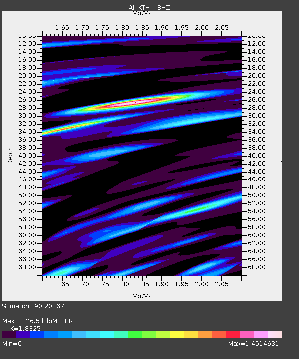
KTH Kantishna Hills - Earthquake Result Viewer

Earthquake location: Near S. Coast Of Honshu, Japan
Earthquake latitude/longitude: 34.6/138.4
Earthquake time(UTC): 2011/08/01 (213) 14:58:09 GMT
Earthquake Depth: 13 km
Earthquake Magnitude: 6.0 MB, 5.6 MS, 5.9 MW, 5.9 MW
Earthquake Catalog/Contributor: WHDF/NEIC
Network: AK Alaska Regional Network
Station: KTH Kantishna Hills
Lat/Lon: 63.55 N/150.92 W
Elevation: 1172 m
Distance: 51.1 deg
Az: 32.886 deg
Baz: 270.659 deg
Ray Param: 0.06762861
Estimated Moho Depth: 26.5 km
Estimated Crust Vp/Vs: 1.83
Assumed Crust Vp: 6.438 km/s
Estimated Crust Vs: 3.513 km/s
Estimated Crust Poisson's Ratio: 0.29
Radial Match: 90.20167 %
Radial Bump: 400
Transverse Match: 79.74214 %
Transverse Bump: 400
SOD ConfigId: 408116
Insert Time: 2012-01-01 02:24:51.483 +0000
GWidth: 2.5
Max Bumps: 400
Tol: 0.001

Signal To Noise

ChannelStoNSTALTA
AK:KTH: :BHZ:20110801T15:06:40.127993Z18.7545661.1869215E-66.328707E-8
AK:KTH: :BHN:20110801T15:06:40.127993Z2.18599461.4462867E-76.61615E-8
AK:KTH: :BHE:20110801T15:06:40.127993Z10.4485645.584874E-75.345111E-8
Arrivals
Ps3.6 SECOND
PpPs11 SECOND
PsPs/PpSs15 SECOND