You are here: Home > Network List > G - GEOSCOPE Stations List
> Station CRZF Port Alfred, Crozet, South Indian Ocean > Earthquake Result Viewer
CRZF Port Alfred, Crozet, South Indian Ocean - Earthquake Result Viewer
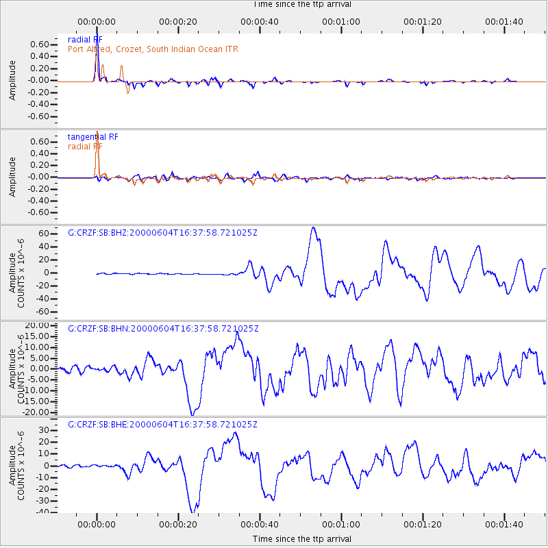
| Earthquake location: |
Southern Sumatra, Indonesia |
| Earthquake latitude/longitude: |
-4.7/102.1 |
| Earthquake time(UTC): |
2000/06/04 (156) 16:28:26 GMT |
| Earthquake Depth: |
33 km |
| Earthquake Magnitude: |
6.8 MB, 8.0 MS, 7.9 MW, 7.7 MW |
| Earthquake Catalog/Contributor: |
WHDF/NEIC |
|
| Network: |
G GEOSCOPE |
| Station: |
CRZF Port Alfred, Crozet, South Indian Ocean |
| Lat/Lon: |
46.43 S/51.86 E |
| Elevation: |
140 m |
|
| Distance: |
60.0 deg |
| Az: |
217.869 deg |
| Baz: |
62.195 deg |
| Ray Param: |
0.06176666 |
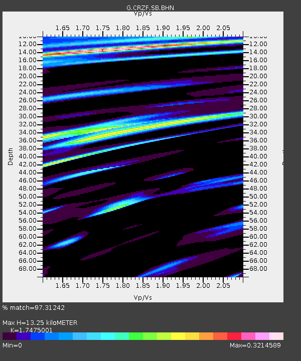
| Estimated Moho Depth: |
13.25 km |
| Estimated Crust Vp/Vs: |
1.75 |
| Assumed Crust Vp: |
4.802 km/s |
| Estimated Crust Vs: |
2.748 km/s |
| Estimated Crust Poisson's Ratio: |
0.26 |
|
| Radial Match: |
97.31242 % |
| Radial Bump: |
248 |
| Transverse Match: |
78.40324 % |
| Transverse Bump: |
400 |
| SOD ConfigId: |
3744 |
| Insert Time: |
2010-02-26 21:55:18.015 +0000 |
| GWidth: |
2.5 |
| Max Bumps: |
400 |
| Tol: |
0.001 |
|
Signal To Noise
| Channel | StoN | STA | LTA |
| G:CRZF:SB:BHN:20000604T16:37:58.721025Z | 1.1725222 | 8.944386E-7 | 7.6283305E-7 |
| G:CRZF:SB:BHE:20000604T16:37:58.721025Z | 0.9612897 | 8.077828E-7 | 8.403115E-7 |
| G:CRZF:SB:BHZ:20000604T16:37:58.721025Z | 1.884628 | 1.0806826E-6 | 5.734196E-7 |
| Arrivals |
| Ps | 2.1 SECOND |
| PpPs | 7.4 SECOND |
| PsPs/PpSs | 9.5 SECOND |


