You are here: Home > Network List > G - GEOSCOPE Stations List
> Station CRZF Port Alfred, Crozet, South Indian Ocean > Earthquake Result Viewer
CRZF Port Alfred, Crozet, South Indian Ocean - Earthquake Result Viewer
| Earthquake location: |
Sulawesi, Indonesia |
| Earthquake latitude/longitude: |
-1.1/123.6 |
| Earthquake time(UTC): |
2000/05/04 (125) 04:21:16 GMT |
| Earthquake Depth: |
26 km |
| Earthquake Magnitude: |
6.7 MB, 7.5 MS, 7.6 MW, 7.5 ME |
| Earthquake Catalog/Contributor: |
WHDF/NEIC |
|
| Network: |
G GEOSCOPE |
| Station: |
CRZF Port Alfred, Crozet, South Indian Ocean |
| Lat/Lon: |
46.43 S/51.86 E |
| Elevation: |
140 m |
|
| Distance: |
76.7 deg |
| Az: |
222.451 deg |
| Baz: |
77.335 deg |
| Ray Param: |
0.050817817 |
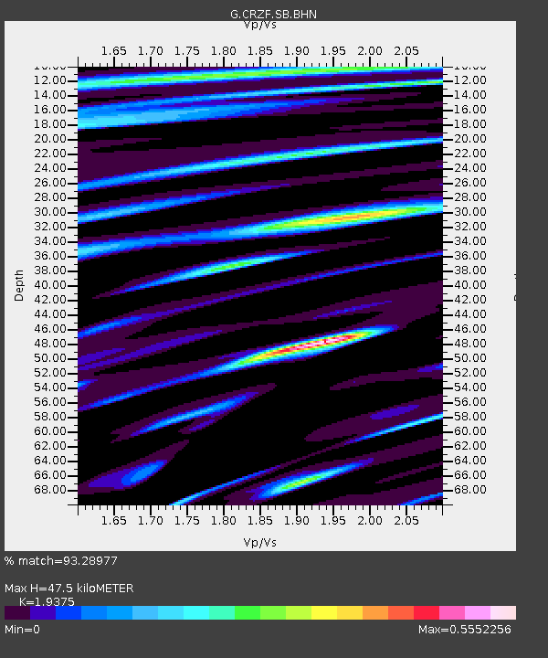
| Estimated Moho Depth: |
47.5 km |
| Estimated Crust Vp/Vs: |
1.94 |
| Assumed Crust Vp: |
4.802 km/s |
| Estimated Crust Vs: |
2.478 km/s |
| Estimated Crust Poisson's Ratio: |
0.32 |
|
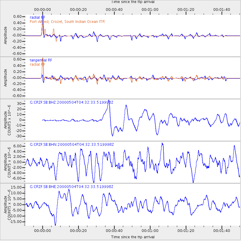
| Radial Match: |
93.28977 % |
| Radial Bump: |
326 |
| Transverse Match: |
72.57154 % |
| Transverse Bump: |
400 |
| SOD ConfigId: |
3744 |
| Insert Time: |
2010-02-26 21:55:19.130 +0000 |
| GWidth: |
2.5 |
| Max Bumps: |
400 |
| Tol: |
0.001 |
|
Signal To Noise
| Channel | StoN | STA | LTA |
| G:CRZF:SB:BHN:20000504T04:32:33.519998Z | 1.0943879 | 1.3016493E-6 | 1.1893857E-6 |
| G:CRZF:SB:BHE:20000504T04:32:33.519998Z | 2.7477212 | 2.9881194E-6 | 1.08749E-6 |
| G:CRZF:SB:BHZ:20000504T04:32:33.519998Z | 5.652457 | 5.024088E-6 | 8.888325E-7 |
| Arrivals |
| Ps | 9.4 SECOND |
| PpPs | 29 SECOND |
| PsPs/PpSs | 38 SECOND |


