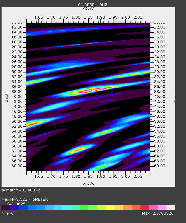
OBSR Observation Rock, Mt. Rainier, WA - Earthquake Result Viewer

Earthquake location: Near S. Coast Of Honshu, Japan
Earthquake latitude/longitude: 34.6/138.4
Earthquake time(UTC): 2011/08/01 (213) 14:58:09 GMT
Earthquake Depth: 13 km
Earthquake Magnitude: 6.0 MB, 5.6 MS, 5.9 MW, 5.9 MW
Earthquake Catalog/Contributor: WHDF/NEIC
Network: CC Cascade Chain Volcano Monitoring
Station: OBSR Observation Rock, Mt. Rainier, WA
Lat/Lon: 46.90 N/121.82 W
Elevation: 2382 m
Distance: 71.6 deg
Az: 45.423 deg
Baz: 301.065 deg
Ray Param: 0.05422744
Estimated Moho Depth: 37.25 km
Estimated Crust Vp/Vs: 1.86
Assumed Crust Vp: 6.597 km/s
Estimated Crust Vs: 3.542 km/s
Estimated Crust Poisson's Ratio: 0.30
Radial Match: 82.40072 %
Radial Bump: 400
Transverse Match: 69.69314 %
Transverse Bump: 400
SOD ConfigId: 408116
Insert Time: 2012-01-01 02:28:54.271 +0000
GWidth: 2.5
Max Bumps: 400
Tol: 0.001

Signal To Noise

ChannelStoNSTALTA
CC:OBSR: :BHZ:20110801T15:08:58.599978Z11.8349941.2452372E-61.05216536E-7
CC:OBSR: :BHN:20110801T15:08:58.599978Z4.28528938.789404E-72.0510642E-7
CC:OBSR: :BHE:20110801T15:08:58.599978Z3.14407445.3694083E-71.7077866E-7
Arrivals
Ps5.0 SECOND
PpPs16 SECOND
PsPs/PpSs21 SECOND