You are here: Home > Network List > G - GEOSCOPE Stations List
> Station CRZF Port Alfred, Crozet, South Indian Ocean > Earthquake Result Viewer
CRZF Port Alfred, Crozet, South Indian Ocean - Earthquake Result Viewer
| Earthquake location: |
Southern India |
| Earthquake latitude/longitude: |
23.4/70.2 |
| Earthquake time(UTC): |
2001/01/26 (026) 03:16:40 GMT |
| Earthquake Depth: |
16 km |
| Earthquake Magnitude: |
6.9 MB, 8.0 MS, 7.7 MW, 7.7 ME |
| Earthquake Catalog/Contributor: |
WHDF/NEIC |
|
| Network: |
G GEOSCOPE |
| Station: |
CRZF Port Alfred, Crozet, South Indian Ocean |
| Lat/Lon: |
46.43 S/51.86 E |
| Elevation: |
140 m |
|
| Distance: |
71.5 deg |
| Az: |
193.291 deg |
| Baz: |
17.777 deg |
| Ray Param: |
0.05428487 |
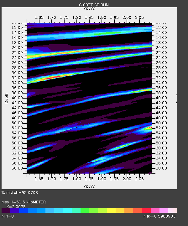
| Estimated Moho Depth: |
51.5 km |
| Estimated Crust Vp/Vs: |
2.10 |
| Assumed Crust Vp: |
4.802 km/s |
| Estimated Crust Vs: |
2.289 km/s |
| Estimated Crust Poisson's Ratio: |
0.35 |
|
| Radial Match: |
95.0708 % |
| Radial Bump: |
342 |
| Transverse Match: |
88.518196 % |
| Transverse Bump: |
400 |
| SOD ConfigId: |
3744 |
| Insert Time: |
2010-02-26 21:55:22.073 +0000 |
| GWidth: |
2.5 |
| Max Bumps: |
400 |
| Tol: |
0.001 |
|
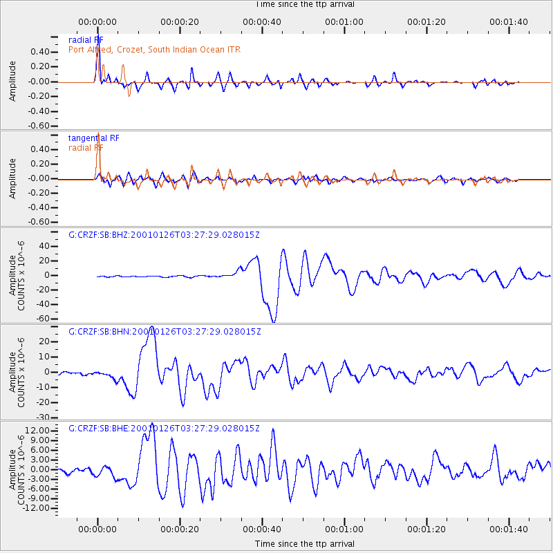
Signal To Noise
| Channel | StoN | STA | LTA |
| G:CRZF:SB:BHN:20010126T03:27:29.028015Z | 3.305379 | 2.7235305E-6 | 8.2396923E-7 |
| G:CRZF:SB:BHE:20010126T03:27:29.028015Z | 1.8656096 | 1.6871261E-6 | 9.043296E-7 |
| G:CRZF:SB:BHZ:20010126T03:27:29.028015Z | 6.1428742 | 5.154652E-6 | 8.3912715E-7 |
| Arrivals |
| Ps | 12 SECOND |
| PpPs | 33 SECOND |
| PsPs/PpSs | 45 SECOND |


