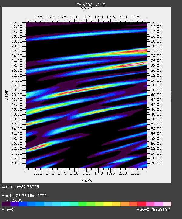
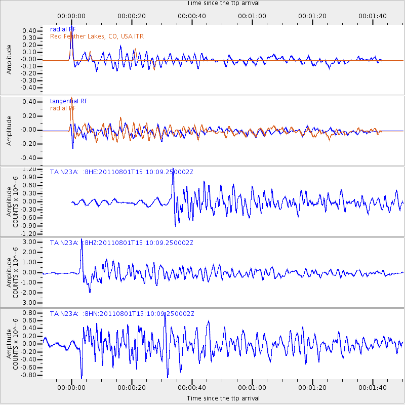
N23A Red Feather Lakes, CO, USA - Earthquake Result Viewer

Earthquake location: Near S. Coast Of Honshu, Japan
Earthquake latitude/longitude: 34.6/138.4
Earthquake time(UTC): 2011/08/01 (213) 14:58:09 GMT
Earthquake Depth: 13 km
Earthquake Magnitude: 6.0 MB, 5.6 MS, 5.9 MW, 5.9 MW
Earthquake Catalog/Contributor: WHDF/NEIC
Network: TA USArray Transportable Network (new EarthScope stations)
Station: N23A Red Feather Lakes, CO, USA
Lat/Lon: 40.89 N/105.94 W
Elevation: 2458 m
Distance: 84.3 deg
Az: 43.384 deg
Baz: 311.655 deg
Ray Param: 0.045547057
Estimated Moho Depth: 26.75 km
Estimated Crust Vp/Vs: 2.09
Assumed Crust Vp: 6.306 km/s
Estimated Crust Vs: 3.024 km/s
Estimated Crust Poisson's Ratio: 0.35
Radial Match: 87.78749 %
Radial Bump: 400
Transverse Match: 86.6733 %
Transverse Bump: 400
SOD ConfigId: 408116
Insert Time: 2012-01-01 02:43:13.578 +0000
GWidth: 2.5
Max Bumps: 400
Tol: 0.001

Signal To Noise

ChannelStoNSTALTA
TA:N23A: :BHZ:20110801T15:10:09.250002Z18.713449.801948E-75.237919E-8
TA:N23A: :BHN:20110801T15:10:09.250002Z3.98553062.7131173E-76.807418E-8
TA:N23A: :BHE:20110801T15:10:09.250002Z6.8175264.1988784E-76.1589475E-8
Arrivals
Ps4.7 SECOND
PpPs13 SECOND
PsPs/PpSs18 SECOND