You are here: Home > Network List > TA - USArray Transportable Network (new EarthScope stations) Stations List
> Station T25A Trinidad, CO, USA > Earthquake Result Viewer
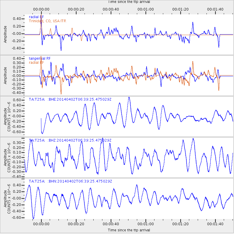
T25A Trinidad, CO, USA - Earthquake Result Viewer
*The percent match for this event was below the threshold and hence no stack was calculated.
| Earthquake location: |
Near Coast Of Northern Chile |
| Earthquake latitude/longitude: |
-20.1/-70.8 |
| Earthquake time(UTC): |
2014/04/02 (092) 06:29:16 GMT |
| Earthquake Depth: |
15 km |
| Earthquake Magnitude: |
5.2 mb |
| Earthquake Catalog/Contributor: |
ISC/ISC |
|
| Network: |
TA USArray Transportable Network (new EarthScope stations) |
| Station: |
T25A Trinidad, CO, USA |
| Lat/Lon: |
37.14 N/104.41 W |
| Elevation: |
2017 m |
|
| Distance: |
65.2 deg |
| Az: |
330.863 deg |
| Baz: |
145.072 deg |
| Ray Param: |
$rayparam |
*The percent match for this event was below the threshold and hence was not used in the summary stack. |
|
| Radial Match: |
43.063225 % |
| Radial Bump: |
364 |
| Transverse Match: |
58.454456 % |
| Transverse Bump: |
400 |
| SOD ConfigId: |
3390531 |
| Insert Time: |
2019-04-11 01:21:28.130 +0000 |
| GWidth: |
2.5 |
| Max Bumps: |
400 |
| Tol: |
0.001 |
|
Signal To Noise
| Channel | StoN | STA | LTA |
| TA:T25A: :BHZ:20140402T06:39:25.475029Z | 0.4908053 | 8.894556E-8 | 1.8122371E-7 |
| TA:T25A: :BHN:20140402T06:39:25.475029Z | 1.7237284 | 2.72787E-7 | 1.5825405E-7 |
| TA:T25A: :BHE:20140402T06:39:25.475029Z | 1.5802379 | 3.166811E-7 | 2.0040092E-7 |
| Arrivals |
| Ps | |
| PpPs | |
| PsPs/PpSs | |


