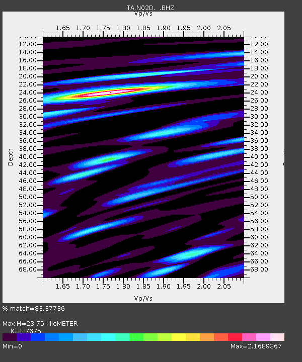
N02D Trinity Center, CA, USA - Earthquake Result Viewer
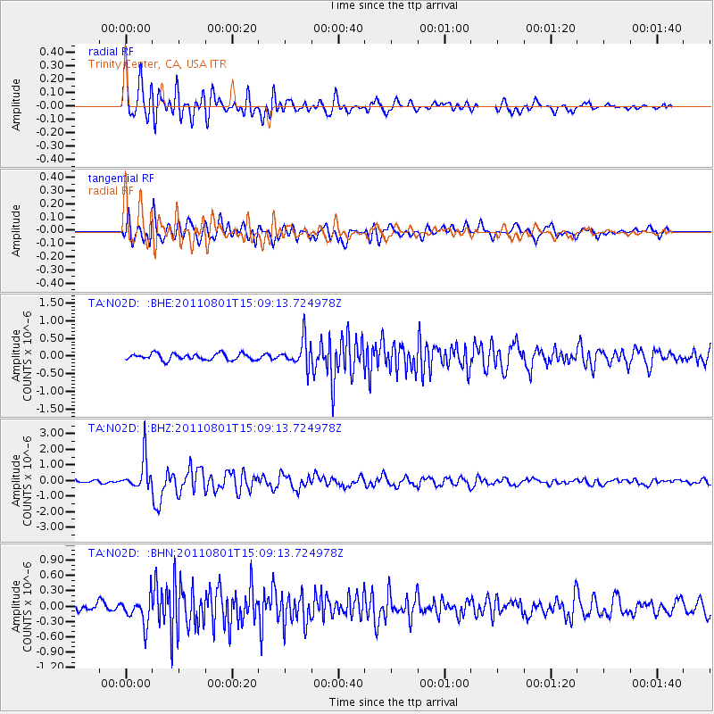
Earthquake location: Near S. Coast Of Honshu, Japan
Earthquake latitude/longitude: 34.6/138.4
Earthquake time(UTC): 2011/08/01 (213) 14:58:09 GMT
Earthquake Depth: 13 km
Earthquake Magnitude: 6.0 MB, 5.6 MS, 5.9 MW, 5.9 MW
Earthquake Catalog/Contributor: WHDF/NEIC
Network: TA USArray Transportable Network (new EarthScope stations)
Station: N02D Trinity Center, CA, USA
Lat/Lon: 40.97 N/122.71 W
Elevation: 937 m
Distance: 74.1 deg
Az: 51.056 deg
Baz: 302.111 deg
Ray Param: 0.052529786
Estimated Moho Depth: 23.75 km
Estimated Crust Vp/Vs: 1.77
Assumed Crust Vp: 6.566 km/s
Estimated Crust Vs: 3.715 km/s
Estimated Crust Poisson's Ratio: 0.26
Radial Match: 83.37736 %
Radial Bump: 400
Transverse Match: 75.399574 %
Transverse Bump: 400
SOD ConfigId: 408116
Insert Time: 2012-01-01 02:47:15.965 +0000
GWidth: 2.5
Max Bumps: 400
Tol: 0.001

Signal To Noise

ChannelStoNSTALTA
TA:N02D: :BHZ:20110801T15:09:13.724978Z11.8123531.0390146E-68.796E-8
TA:N02D: :BHN:20110801T15:09:13.724978Z3.86042282.6943204E-76.97934E-8
TA:N02D: :BHE:20110801T15:09:13.724978Z4.3138863.873749E-78.979721E-8
Arrivals
Ps2.9 SECOND
PpPs9.7 SECOND
PsPs/PpSs13 SECOND