You are here: Home > Network List > TA - USArray Transportable Network (new EarthScope stations) Stations List
> Station V61A Roper, NC, USA > Earthquake Result Viewer
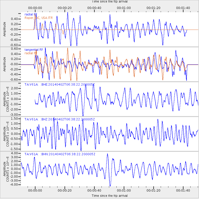
V61A Roper, NC, USA - Earthquake Result Viewer
*The percent match for this event was below the threshold and hence no stack was calculated.
| Earthquake location: |
Near Coast Of Northern Chile |
| Earthquake latitude/longitude: |
-20.1/-70.8 |
| Earthquake time(UTC): |
2014/04/02 (092) 06:29:16 GMT |
| Earthquake Depth: |
15 km |
| Earthquake Magnitude: |
5.2 mb |
| Earthquake Catalog/Contributor: |
ISC/ISC |
|
| Network: |
TA USArray Transportable Network (new EarthScope stations) |
| Station: |
V61A Roper, NC, USA |
| Lat/Lon: |
35.79 N/76.58 W |
| Elevation: |
4.0 m |
|
| Distance: |
55.9 deg |
| Az: |
354.368 deg |
| Baz: |
173.487 deg |
| Ray Param: |
$rayparam |
*The percent match for this event was below the threshold and hence was not used in the summary stack. |
|
| Radial Match: |
67.81338 % |
| Radial Bump: |
400 |
| Transverse Match: |
58.539993 % |
| Transverse Bump: |
400 |
| SOD ConfigId: |
3390531 |
| Insert Time: |
2019-04-11 01:21:32.996 +0000 |
| GWidth: |
2.5 |
| Max Bumps: |
400 |
| Tol: |
0.001 |
|
Signal To Noise
| Channel | StoN | STA | LTA |
| TA:V61A: :BHZ:20140402T06:38:22.200005Z | 1.6079417 | 6.25338E-7 | 3.8890587E-7 |
| TA:V61A: :BHN:20140402T06:38:22.200005Z | 2.1500254 | 1.5774691E-6 | 7.336979E-7 |
| TA:V61A: :BHE:20140402T06:38:22.200005Z | 2.2465591 | 1.8227984E-6 | 8.1137347E-7 |
| Arrivals |
| Ps | |
| PpPs | |
| PsPs/PpSs | |


