You are here: Home > Network List > TA - USArray Transportable Network (new EarthScope stations) Stations List
> Station Y38A Idabel, OK, USA > Earthquake Result Viewer
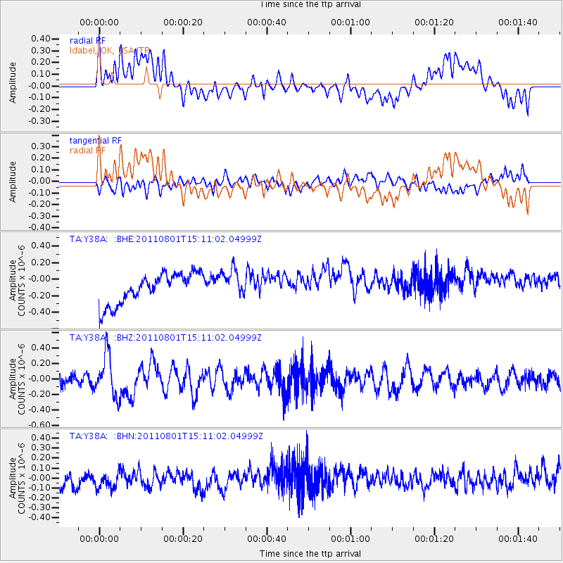
Y38A Idabel, OK, USA - Earthquake Result Viewer
*The percent match for this event was below the threshold and hence no stack was calculated.
| Earthquake location: |
Near S. Coast Of Honshu, Japan |
| Earthquake latitude/longitude: |
34.6/138.4 |
| Earthquake time(UTC): |
2011/08/01 (213) 14:58:09 GMT |
| Earthquake Depth: |
13 km |
| Earthquake Magnitude: |
6.0 MB, 5.6 MS, 5.9 MW, 5.9 MW |
| Earthquake Catalog/Contributor: |
WHDF/NEIC |
|
| Network: |
TA USArray Transportable Network (new EarthScope stations) |
| Station: |
Y38A Idabel, OK, USA |
| Lat/Lon: |
33.93 N/94.73 W |
| Elevation: |
118 m |
|
| Distance: |
95.6 deg |
| Az: |
41.96 deg |
| Baz: |
318.464 deg |
| Ray Param: |
$rayparam |
*The percent match for this event was below the threshold and hence was not used in the summary stack. |
|
| Radial Match: |
33.691017 % |
| Radial Bump: |
400 |
| Transverse Match: |
41.41934 % |
| Transverse Bump: |
400 |
| SOD ConfigId: |
408116 |
| Insert Time: |
2012-01-01 02:52:14.270 +0000 |
| GWidth: |
2.5 |
| Max Bumps: |
400 |
| Tol: |
0.001 |
|
Signal To Noise
| Channel | StoN | STA | LTA |
| TA:Y38A: :BHZ:20110801T15:11:02.04999Z | 3.8946495 | 2.7886531E-7 | 7.1602166E-8 |
| TA:Y38A: :BHN:20110801T15:11:02.04999Z | 1.0171688 | 1.2254462E-7 | 1.2047619E-7 |
| TA:Y38A: :BHE:20110801T15:11:02.04999Z | 0.9596289 | 1.7358822E-7 | 1.8089099E-7 |
| Arrivals |
| Ps | |
| PpPs | |
| PsPs/PpSs | |


