You are here: Home > Network List > TA - USArray Transportable Network (new EarthScope stations) Stations List
> Station R35A Emporia Municipal Airport, Emporia, KS, USA > Earthquake Result Viewer
R35A Emporia Municipal Airport, Emporia, KS, USA - Earthquake Result Viewer
| Earthquake location: |
Near S. Coast Of Honshu, Japan |
| Earthquake latitude/longitude: |
34.6/138.4 |
| Earthquake time(UTC): |
2011/08/01 (213) 14:58:09 GMT |
| Earthquake Depth: |
13 km |
| Earthquake Magnitude: |
6.0 MB, 5.6 MS, 5.9 MW, 5.9 MW |
| Earthquake Catalog/Contributor: |
WHDF/NEIC |
|
| Network: |
TA USArray Transportable Network (new EarthScope stations) |
| Station: |
R35A Emporia Municipal Airport, Emporia, KS, USA |
| Lat/Lon: |
38.32 N/96.20 W |
| Elevation: |
365 m |
|
| Distance: |
91.5 deg |
| Az: |
39.912 deg |
| Baz: |
317.728 deg |
| Ray Param: |
0.041597527 |
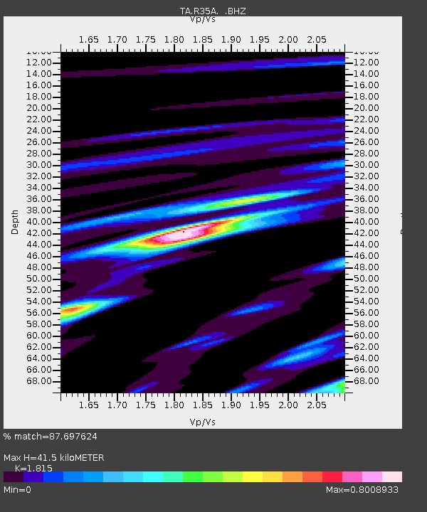
| Estimated Moho Depth: |
41.5 km |
| Estimated Crust Vp/Vs: |
1.82 |
| Assumed Crust Vp: |
6.483 km/s |
| Estimated Crust Vs: |
3.572 km/s |
| Estimated Crust Poisson's Ratio: |
0.28 |
|
| Radial Match: |
87.697624 % |
| Radial Bump: |
360 |
| Transverse Match: |
62.13878 % |
| Transverse Bump: |
400 |
| SOD ConfigId: |
408116 |
| Insert Time: |
2012-01-01 02:53:36.852 +0000 |
| GWidth: |
2.5 |
| Max Bumps: |
400 |
| Tol: |
0.001 |
|

Signal To Noise
| Channel | StoN | STA | LTA |
| TA:R35A: :BHZ:20110801T15:10:43.500002Z | 6.0002813 | 9.773389E-7 | 1.6288217E-7 |
| TA:R35A: :BHN:20110801T15:10:43.500002Z | 2.6314774 | 2.884805E-7 | 1.09626825E-7 |
| TA:R35A: :BHE:20110801T15:10:43.500002Z | 2.3362877 | 2.5521976E-7 | 1.0924158E-7 |
| Arrivals |
| Ps | 5.3 SECOND |
| PpPs | 18 SECOND |
| PsPs/PpSs | 23 SECOND |


