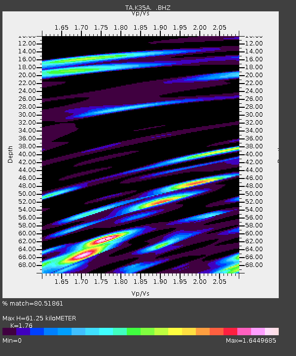
K35A Storm Lake, IA, USA - Earthquake Result Viewer

Earthquake location: Near S. Coast Of Honshu, Japan
Earthquake latitude/longitude: 34.6/138.4
Earthquake time(UTC): 2011/08/01 (213) 14:58:09 GMT
Earthquake Depth: 13 km
Earthquake Magnitude: 6.0 MB, 5.6 MS, 5.9 MW, 5.9 MW
Earthquake Catalog/Contributor: WHDF/NEIC
Network: TA USArray Transportable Network (new EarthScope stations)
Station: K35A Storm Lake, IA, USA
Lat/Lon: 42.72 N/95.23 W
Elevation: 439 m
Distance: 88.7 deg
Az: 36.427 deg
Baz: 318.36 deg
Ray Param: 0.042372152
Estimated Moho Depth: 61.25 km
Estimated Crust Vp/Vs: 1.76
Assumed Crust Vp: 6.53 km/s
Estimated Crust Vs: 3.71 km/s
Estimated Crust Poisson's Ratio: 0.26
Radial Match: 80.51861 %
Radial Bump: 400
Transverse Match: 65.71551 %
Transverse Bump: 400
SOD ConfigId: 408116
Insert Time: 2012-01-01 02:56:33.612 +0000
GWidth: 2.5
Max Bumps: 400
Tol: 0.001

Signal To Noise

ChannelStoNSTALTA
TA:K35A: :BHZ:20110801T15:10:30.599978Z5.7305237.175219E-71.2521055E-7
TA:K35A: :BHN:20110801T15:10:30.599978Z2.86590723.7595507E-71.3118188E-7
TA:K35A: :BHE:20110801T15:10:30.599978Z2.76196843.5298635E-71.2780247E-7
Arrivals
Ps7.3 SECOND
PpPs25 SECOND
PsPs/PpSs33 SECOND