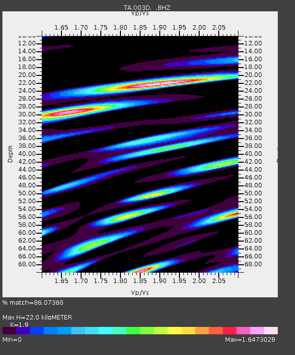
O03D Paynes Creek, CA, USA - Earthquake Result Viewer
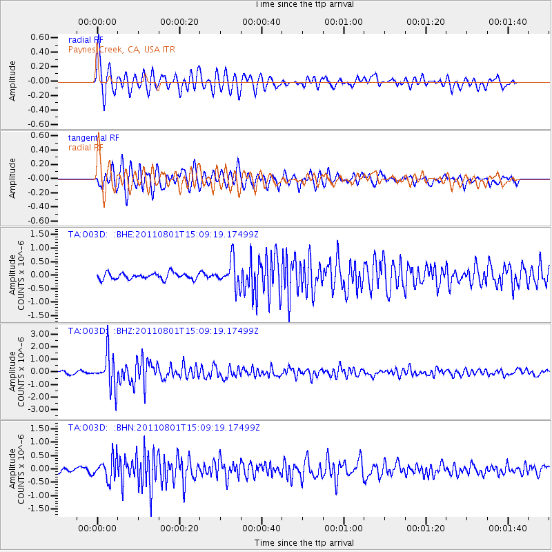
Earthquake location: Near S. Coast Of Honshu, Japan
Earthquake latitude/longitude: 34.6/138.4
Earthquake time(UTC): 2011/08/01 (213) 14:58:09 GMT
Earthquake Depth: 13 km
Earthquake Magnitude: 6.0 MB, 5.6 MS, 5.9 MW, 5.9 MW
Earthquake Catalog/Contributor: WHDF/NEIC
Network: TA USArray Transportable Network (new EarthScope stations)
Station: O03D Paynes Creek, CA, USA
Lat/Lon: 40.29 N/121.80 W
Elevation: 968 m
Distance: 75.1 deg
Az: 51.268 deg
Baz: 302.753 deg
Ray Param: 0.051898714
Estimated Moho Depth: 22.0 km
Estimated Crust Vp/Vs: 1.90
Assumed Crust Vp: 6.566 km/s
Estimated Crust Vs: 3.456 km/s
Estimated Crust Poisson's Ratio: 0.31
Radial Match: 86.07368 %
Radial Bump: 400
Transverse Match: 81.41603 %
Transverse Bump: 400
SOD ConfigId: 408116
Insert Time: 2012-01-01 02:57:24.709 +0000
GWidth: 2.5
Max Bumps: 400
Tol: 0.001

Signal To Noise

ChannelStoNSTALTA
TA:O03D: :BHZ:20110801T15:09:19.17499Z15.0414121.375114E-69.142187E-8
TA:O03D: :BHN:20110801T15:09:19.17499Z4.79422434.198849E-78.758141E-8
TA:O03D: :BHE:20110801T15:09:19.17499Z4.23757174.953409E-71.16892615E-7
Arrivals
Ps3.1 SECOND
PpPs9.4 SECOND
PsPs/PpSs13 SECOND