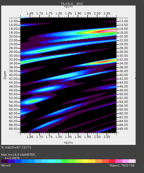
K31A O'Neill, NE, USA - Earthquake Result Viewer

Earthquake location: Near S. Coast Of Honshu, Japan
Earthquake latitude/longitude: 34.6/138.4
Earthquake time(UTC): 2011/08/01 (213) 14:58:09 GMT
Earthquake Depth: 13 km
Earthquake Magnitude: 6.0 MB, 5.6 MS, 5.9 MW, 5.9 MW
Earthquake Catalog/Contributor: WHDF/NEIC
Network: TA USArray Transportable Network (new EarthScope stations)
Station: K31A O'Neill, NE, USA
Lat/Lon: 42.62 N/98.75 W
Elevation: 580 m
Distance: 87.0 deg
Az: 38.401 deg
Baz: 316.054 deg
Ray Param: 0.04361656
Estimated Moho Depth: 16.5 km
Estimated Crust Vp/Vs: 2.10
Assumed Crust Vp: 6.53 km/s
Estimated Crust Vs: 3.113 km/s
Estimated Crust Poisson's Ratio: 0.35
Radial Match: 87.72173 %
Radial Bump: 400
Transverse Match: 88.1631 %
Transverse Bump: 400
SOD ConfigId: 408116
Insert Time: 2012-01-01 02:58:51.011 +0000
GWidth: 2.5
Max Bumps: 400
Tol: 0.001

Signal To Noise

ChannelStoNSTALTA
TA:K31A: :BHZ:20110801T15:10:22.525027Z12.2748991.2058536E-69.823736E-8
TA:K31A: :BHN:20110801T15:10:22.525027Z3.93725686.6660147E-71.6930606E-7
TA:K31A: :BHE:20110801T15:10:22.525027Z2.68738464.786492E-71.7810967E-7
Arrivals
Ps2.8 SECOND
PpPs7.7 SECOND
PsPs/PpSs11 SECOND