You are here: Home > Network List > TA - USArray Transportable Network (new EarthScope stations) Stations List
> Station C38A Sawbill Landing (USFS), Superior Nat. Forest, MN, > Earthquake Result Viewer
C38A Sawbill Landing (USFS), Superior Nat. Forest, MN, - Earthquake Result Viewer

| Earthquake location: |
Near S. Coast Of Honshu, Japan |
| Earthquake latitude/longitude: |
34.6/138.4 |
| Earthquake time(UTC): |
2011/08/01 (213) 14:58:09 GMT |
| Earthquake Depth: |
13 km |
| Earthquake Magnitude: |
6.0 MB, 5.6 MS, 5.9 MW, 5.9 MW |
| Earthquake Catalog/Contributor: |
WHDF/NEIC |
|
| Network: |
TA USArray Transportable Network (new EarthScope stations) |
| Station: |
C38A Sawbill Landing (USFS), Superior Nat. Forest, MN, |
| Lat/Lon: |
47.72 N/91.27 W |
| Elevation: |
498 m |
|
| Distance: |
86.7 deg |
| Az: |
31.057 deg |
| Baz: |
320.951 deg |
| Ray Param: |
0.043838438 |
| Estimated Moho Depth: |
39.5 km |
| Estimated Crust Vp/Vs: |
1.64 |
| Assumed Crust Vp: |
6.467 km/s |
| Estimated Crust Vs: |
3.931 km/s |
| Estimated Crust Poisson's Ratio: |
0.21 |
|
| Radial Match: |
82.01332 % |
| Radial Bump: |
332 |
| Transverse Match: |
74.73984 % |
| Transverse Bump: |
400 |
| SOD ConfigId: |
408116 |
| Insert Time: |
2012-01-01 03:01:42.503 +0000 |
| GWidth: |
2.5 |
| Max Bumps: |
400 |
| Tol: |
0.001 |
|
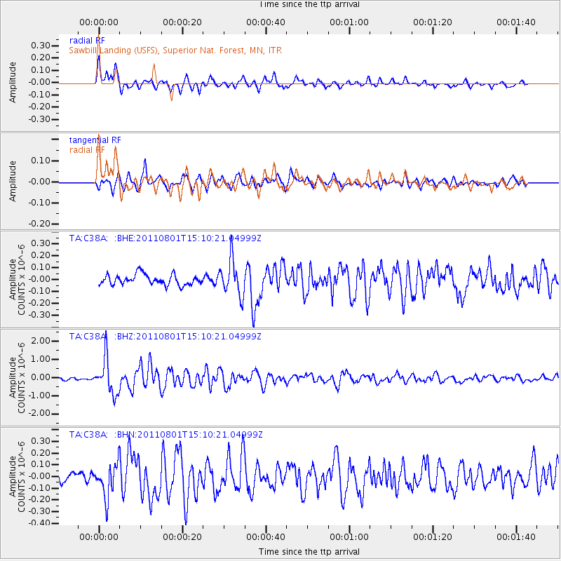
Signal To Noise
| Channel | StoN | STA | LTA |
| TA:C38A: :BHZ:20110801T15:10:21.04999Z | 11.346371 | 1.0028303E-6 | 8.838335E-8 |
| TA:C38A: :BHN:20110801T15:10:21.04999Z | 2.1558006 | 1.4412356E-7 | 6.685385E-8 |
| TA:C38A: :BHE:20110801T15:10:21.04999Z | 3.5512087 | 1.5253374E-7 | 4.2952628E-8 |
| Arrivals |
| Ps | 4.0 SECOND |
| PpPs | 16 SECOND |
| PsPs/PpSs | 20 SECOND |


