You are here: Home > Network List > TA - USArray Transportable Network (new EarthScope stations) Stations List
> Station J37A Redenius Farm, Forest, IA, USA > Earthquake Result Viewer
J37A Redenius Farm, Forest, IA, USA - Earthquake Result Viewer
*The percent match for this event was below the threshold and hence no stack was calculated.
| Earthquake location: |
Near S. Coast Of Honshu, Japan |
| Earthquake latitude/longitude: |
34.6/138.4 |
| Earthquake time(UTC): |
2011/08/01 (213) 14:58:09 GMT |
| Earthquake Depth: |
13 km |
| Earthquake Magnitude: |
6.0 MB, 5.6 MS, 5.9 MW, 5.9 MW |
| Earthquake Catalog/Contributor: |
WHDF/NEIC |
|
| Network: |
TA USArray Transportable Network (new EarthScope stations) |
| Station: |
J37A Redenius Farm, Forest, IA, USA |
| Lat/Lon: |
43.31 N/93.55 W |
| Elevation: |
385 m |
|
| Distance: |
89.1 deg |
| Az: |
35.111 deg |
| Baz: |
319.477 deg |
| Ray Param: |
$rayparam |
*The percent match for this event was below the threshold and hence was not used in the summary stack. |
|
| Radial Match: |
68.523674 % |
| Radial Bump: |
400 |
| Transverse Match: |
64.40215 % |
| Transverse Bump: |
400 |
| SOD ConfigId: |
408116 |
| Insert Time: |
2012-01-01 03:02:22.574 +0000 |
| GWidth: |
2.5 |
| Max Bumps: |
400 |
| Tol: |
0.001 |
|
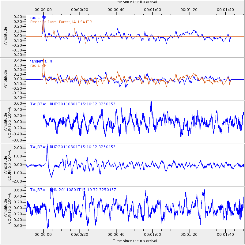
Signal To Noise
| Channel | StoN | STA | LTA |
| TA:J37A: :BHZ:20110801T15:10:32.325015Z | 7.326855 | 9.558669E-7 | 1.3046072E-7 |
| TA:J37A: :BHN:20110801T15:10:32.325015Z | 2.6364563 | 3.604166E-7 | 1.3670494E-7 |
| TA:J37A: :BHE:20110801T15:10:32.325015Z | 1.4815078 | 2.3079478E-7 | 1.5578371E-7 |
| Arrivals |
| Ps | |
| PpPs | |
| PsPs/PpSs | |


