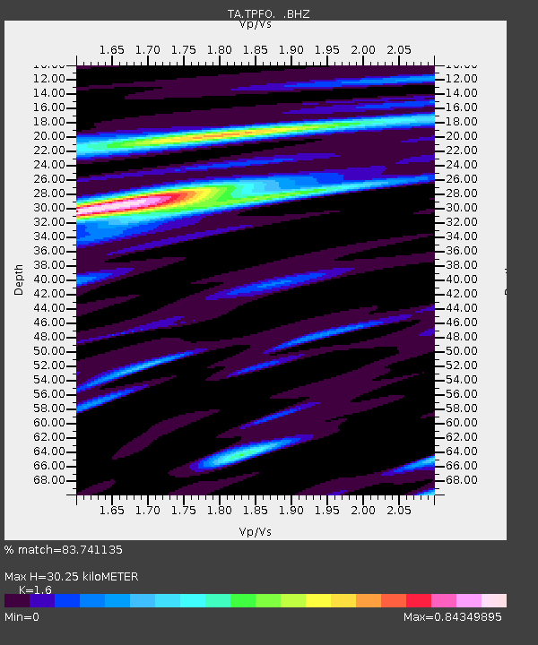
TPFO Pinon Flats, CA, USA - Earthquake Result Viewer
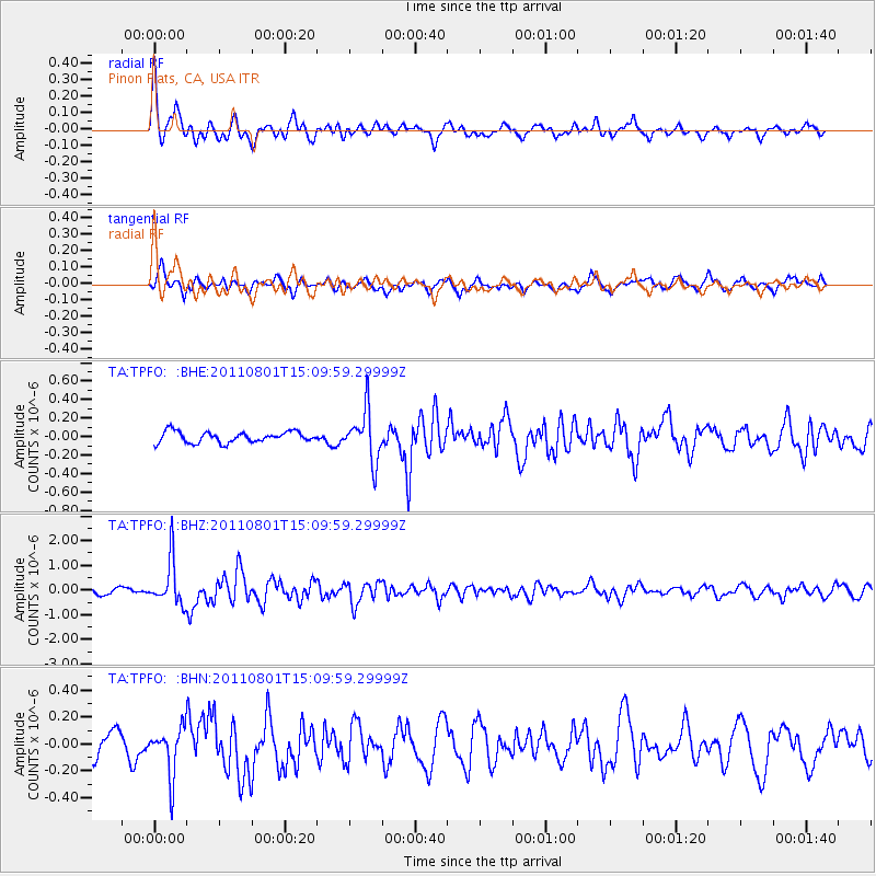
Earthquake location: Near S. Coast Of Honshu, Japan
Earthquake latitude/longitude: 34.6/138.4
Earthquake time(UTC): 2011/08/01 (213) 14:58:09 GMT
Earthquake Depth: 13 km
Earthquake Magnitude: 6.0 MB, 5.6 MS, 5.9 MW, 5.9 MW
Earthquake Catalog/Contributor: WHDF/NEIC
Network: TA USArray Transportable Network (new EarthScope stations)
Station: TPFO Pinon Flats, CA, USA
Lat/Lon: 33.61 N/116.45 W
Elevation: 1275 m
Distance: 82.4 deg
Az: 54.375 deg
Baz: 306.569 deg
Ray Param: 0.046906985
Estimated Moho Depth: 30.25 km
Estimated Crust Vp/Vs: 1.60
Assumed Crust Vp: 6.264 km/s
Estimated Crust Vs: 3.915 km/s
Estimated Crust Poisson's Ratio: 0.18
Radial Match: 83.741135 %
Radial Bump: 400
Transverse Match: 78.5464 %
Transverse Bump: 400
SOD ConfigId: 408116
Insert Time: 2012-01-01 03:08:17.054 +0000
GWidth: 2.5
Max Bumps: 400
Tol: 0.001

Signal To Noise

ChannelStoNSTALTA
TA:TPFO: :BHZ:20110801T15:09:59.29999Z5.63099589.0945565E-71.6150885E-7
TA:TPFO: :BHN:20110801T15:09:59.29999Z1.95247751.7877993E-79.156568E-8
TA:TPFO: :BHE:20110801T15:09:59.29999Z4.56933742.689577E-75.886142E-8
Arrivals
Ps3.0 SECOND
PpPs12 SECOND
PsPs/PpSs15 SECOND