You are here: Home > Network List > G - GEOSCOPE Stations List
> Station CRZF Port Alfred, Crozet, South Indian Ocean > Earthquake Result Viewer
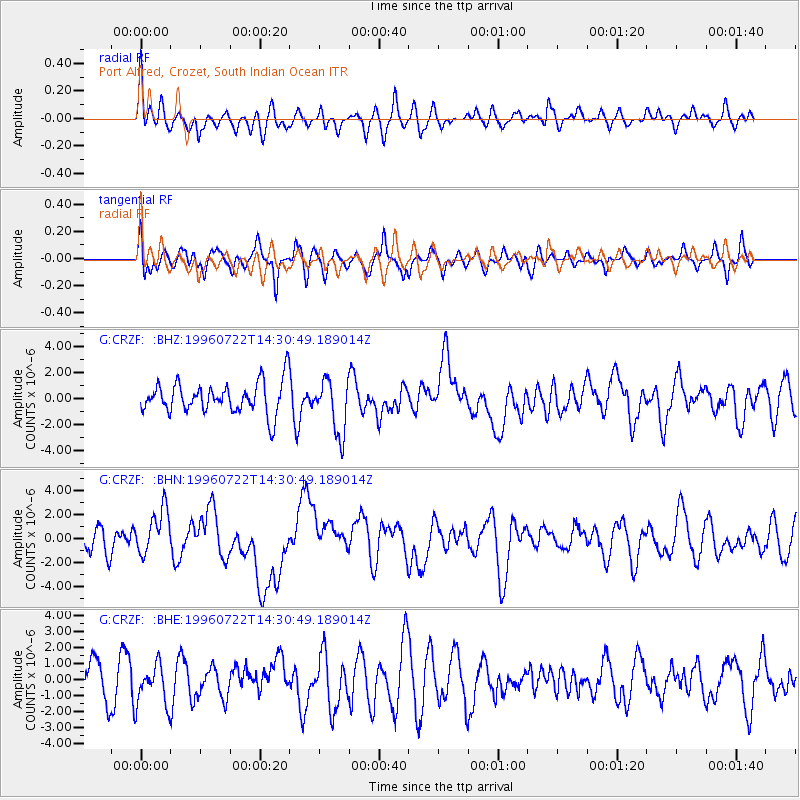
CRZF Port Alfred, Crozet, South Indian Ocean - Earthquake Result Viewer
*The percent match for this event was below the threshold and hence no stack was calculated.
| Earthquake location: |
Minahassa Peninsula, Sulawesi |
| Earthquake latitude/longitude: |
1.0/120.4 |
| Earthquake time(UTC): |
1996/07/22 (204) 14:19:35 GMT |
| Earthquake Depth: |
33 km |
| Earthquake Magnitude: |
6.0 MB, 6.9 MS, 7.0 UNKNOWN, 6.9 MW |
| Earthquake Catalog/Contributor: |
WHDF/NEIC |
|
| Network: |
G GEOSCOPE |
| Station: |
CRZF Port Alfred, Crozet, South Indian Ocean |
| Lat/Lon: |
46.43 S/51.86 E |
| Elevation: |
140 m |
|
| Distance: |
76.1 deg |
| Az: |
221.553 deg |
| Baz: |
73.507 deg |
| Ray Param: |
$rayparam |
*The percent match for this event was below the threshold and hence was not used in the summary stack. |
|
| Radial Match: |
57.819862 % |
| Radial Bump: |
400 |
| Transverse Match: |
51.803684 % |
| Transverse Bump: |
400 |
| SOD ConfigId: |
4480 |
| Insert Time: |
2010-02-26 21:56:45.503 +0000 |
| GWidth: |
2.5 |
| Max Bumps: |
400 |
| Tol: |
0.001 |
|
Signal To Noise
| Channel | StoN | STA | LTA |
| G:CRZF: :BHN:19960722T14:30:49.189014Z | 2.2693694 | 1.9167333E-6 | 8.446105E-7 |
| G:CRZF: :BHE:19960722T14:30:49.189014Z | 0.883172 | 1.2628692E-6 | 1.4299245E-6 |
| G:CRZF: :BHZ:19960722T14:30:49.189014Z | 1.7389776 | 2.0848875E-6 | 1.1989157E-6 |
| Arrivals |
| Ps | |
| PpPs | |
| PsPs/PpSs | |


