You are here: Home > Network List > TA - USArray Transportable Network (new EarthScope stations) Stations List
> Station L02D Cave Junction, OR, USA > Earthquake Result Viewer
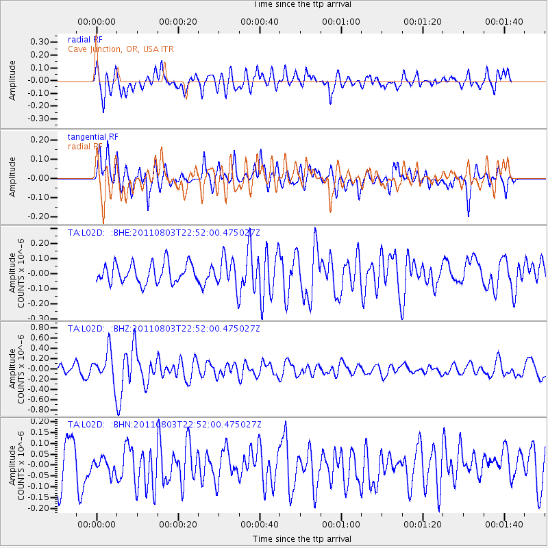
L02D Cave Junction, OR, USA - Earthquake Result Viewer
*The percent match for this event was below the threshold and hence no stack was calculated.
| Earthquake location: |
New Britain Region, P.N.G. |
| Earthquake latitude/longitude: |
-5.0/148.2 |
| Earthquake time(UTC): |
2011/08/03 (215) 22:39:23 GMT |
| Earthquake Depth: |
10 km |
| Earthquake Magnitude: |
5.8 MB, 5.5 MS, 5.7 MW, 5.7 MW |
| Earthquake Catalog/Contributor: |
WHDF/NEIC |
|
| Network: |
TA USArray Transportable Network (new EarthScope stations) |
| Station: |
L02D Cave Junction, OR, USA |
| Lat/Lon: |
42.16 N/123.60 W |
| Elevation: |
458 m |
|
| Distance: |
92.0 deg |
| Az: |
48.044 deg |
| Baz: |
265.095 deg |
| Ray Param: |
$rayparam |
*The percent match for this event was below the threshold and hence was not used in the summary stack. |
|
| Radial Match: |
66.062996 % |
| Radial Bump: |
400 |
| Transverse Match: |
66.32947 % |
| Transverse Bump: |
400 |
| SOD ConfigId: |
408116 |
| Insert Time: |
2012-01-01 03:30:19.132 +0000 |
| GWidth: |
2.5 |
| Max Bumps: |
400 |
| Tol: |
0.001 |
|
Signal To Noise
| Channel | StoN | STA | LTA |
| TA:L02D: :BHZ:20110803T22:52:00.475027Z | 3.120819 | 3.185832E-7 | 1.0208319E-7 |
| TA:L02D: :BHN:20110803T22:52:00.475027Z | 0.5149318 | 4.5455685E-8 | 8.827515E-8 |
| TA:L02D: :BHE:20110803T22:52:00.475027Z | 1.5476024 | 1.0026697E-7 | 6.478858E-8 |
| Arrivals |
| Ps | |
| PpPs | |
| PsPs/PpSs | |


