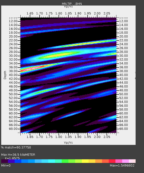
TIP Timpagrande, Italy - Earthquake Result Viewer

Earthquake location: Southern Sumatra, Indonesia
Earthquake latitude/longitude: -2.8/101.1
Earthquake time(UTC): 2011/08/04 (216) 00:16:07 GMT
Earthquake Depth: 35 km
Earthquake Magnitude: 5.8 MB, 5.5 MS, 5.8 MW, 5.6 MW
Earthquake Catalog/Contributor: WHDF/NEIC
Network: MN MEDNET Project
Station: TIP Timpagrande, Italy
Lat/Lon: 39.18 N/16.76 E
Elevation: 789 m
Distance: 87.4 deg
Az: 309.263 deg
Baz: 95.762 deg
Ray Param: 0.04332285
Estimated Moho Depth: 36.5 km
Estimated Crust Vp/Vs: 1.66
Assumed Crust Vp: 6.1 km/s
Estimated Crust Vs: 3.68 km/s
Estimated Crust Poisson's Ratio: 0.21
Radial Match: 90.37758 %
Radial Bump: 400
Transverse Match: 85.44689 %
Transverse Bump: 400
SOD ConfigId: 408116
Insert Time: 2012-01-01 03:39:09.609 +0000
GWidth: 2.5
Max Bumps: 400
Tol: 0.001

Signal To Noise

ChannelStoNSTALTA
MN:TIP: :BHZ:20110804T00:28:19.751982Z8.2379395.679933E-76.8948474E-8
MN:TIP: :BHN:20110804T00:28:19.751982Z1.6973577.917098E-84.6643684E-8
MN:TIP: :BHE:20110804T00:28:19.751982Z4.8021972.1672669E-74.513074E-8
Arrivals
Ps4.0 SECOND
PpPs16 SECOND
PsPs/PpSs20 SECOND