You are here: Home > Network List > AR - Northern Arizona Network Stations List
> Station U15A North Rim, AZ, USA > Earthquake Result Viewer
U15A North Rim, AZ, USA - Earthquake Result Viewer
| Earthquake location: |
Kuril Islands |
| Earthquake latitude/longitude: |
48.8/154.8 |
| Earthquake time(UTC): |
2011/08/04 (216) 13:51:34 GMT |
| Earthquake Depth: |
36 km |
| Earthquake Magnitude: |
6.0 MB, 5.8 MS, 6.1 MW, 6.0 MW |
| Earthquake Catalog/Contributor: |
WHDF/NEIC |
|
| Network: |
AR Northern Arizona Network |
| Station: |
U15A North Rim, AZ, USA |
| Lat/Lon: |
36.43 N/112.29 W |
| Elevation: |
2489 m |
|
| Distance: |
65.4 deg |
| Az: |
62.365 deg |
| Baz: |
313.463 deg |
| Ray Param: |
0.05824268 |
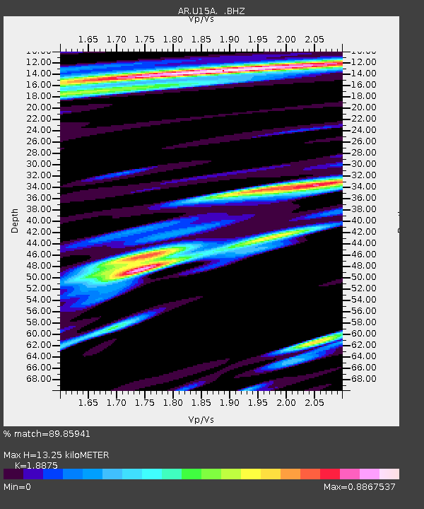
| Estimated Moho Depth: |
13.25 km |
| Estimated Crust Vp/Vs: |
1.89 |
| Assumed Crust Vp: |
6.194 km/s |
| Estimated Crust Vs: |
3.282 km/s |
| Estimated Crust Poisson's Ratio: |
0.30 |
|
| Radial Match: |
89.85941 % |
| Radial Bump: |
400 |
| Transverse Match: |
83.783485 % |
| Transverse Bump: |
400 |
| SOD ConfigId: |
408116 |
| Insert Time: |
2012-01-01 03:42:33.962 +0000 |
| GWidth: |
2.5 |
| Max Bumps: |
400 |
| Tol: |
0.001 |
|

Signal To Noise
| Channel | StoN | STA | LTA |
| AR:U15A: :BHZ:20110804T14:01:42.650027Z | 9.447585 | 9.3532043E-7 | 9.900101E-8 |
| AR:U15A: :BHN:20110804T14:01:42.650027Z | 2.5783572 | 1.951556E-7 | 7.568989E-8 |
| AR:U15A: :BHE:20110804T14:01:42.650027Z | 5.0949717 | 2.996603E-7 | 5.881491E-8 |
| Arrivals |
| Ps | 2.0 SECOND |
| PpPs | 6.0 SECOND |
| PsPs/PpSs | 7.9 SECOND |


