You are here: Home > Network List > GB - Great Britain Seismograph Network Stations List
> Station GAL1 GALLOWAY, SCOTLAND > Earthquake Result Viewer
GAL1 GALLOWAY, SCOTLAND - Earthquake Result Viewer
| Earthquake location: |
Kuril Islands |
| Earthquake latitude/longitude: |
48.8/154.8 |
| Earthquake time(UTC): |
2011/08/04 (216) 13:51:34 GMT |
| Earthquake Depth: |
36 km |
| Earthquake Magnitude: |
6.0 MB, 5.8 MS, 6.1 MW, 6.0 MW |
| Earthquake Catalog/Contributor: |
WHDF/NEIC |
|
| Network: |
GB Great Britain Seismograph Network |
| Station: |
GAL1 GALLOWAY, SCOTLAND |
| Lat/Lon: |
54.87 N/4.71 W |
| Elevation: |
117 m |
|
| Distance: |
75.2 deg |
| Az: |
347.904 deg |
| Baz: |
13.858 deg |
| Ray Param: |
0.05174714 |
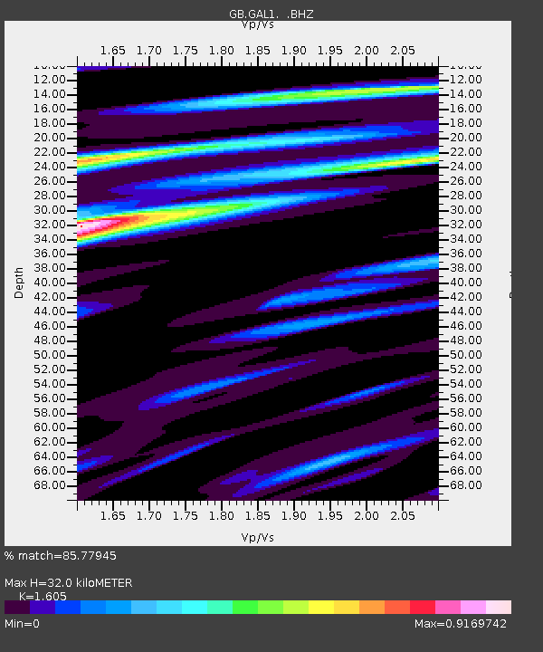
| Estimated Moho Depth: |
32.0 km |
| Estimated Crust Vp/Vs: |
1.61 |
| Assumed Crust Vp: |
6.276 km/s |
| Estimated Crust Vs: |
3.91 km/s |
| Estimated Crust Poisson's Ratio: |
0.18 |
|
| Radial Match: |
85.77945 % |
| Radial Bump: |
400 |
| Transverse Match: |
72.26171 % |
| Transverse Bump: |
400 |
| SOD ConfigId: |
408116 |
| Insert Time: |
2012-01-01 03:52:08.245 +0000 |
| GWidth: |
2.5 |
| Max Bumps: |
400 |
| Tol: |
0.001 |
|

Signal To Noise
| Channel | StoN | STA | LTA |
| GB:GAL1: :BHZ:20110804T14:02:42.67499Z | 11.83851 | 6.776063E-7 | 5.7237465E-8 |
| GB:GAL1: :BHN:20110804T14:02:42.67499Z | 4.2470713 | 2.4952575E-7 | 5.875243E-8 |
| GB:GAL1: :BHE:20110804T14:02:42.67499Z | 1.7502967 | 9.9803216E-8 | 5.702074E-8 |
| Arrivals |
| Ps | 3.2 SECOND |
| PpPs | 13 SECOND |
| PsPs/PpSs | 16 SECOND |


