You are here: Home > Network List > IC - New China Digital Seismograph Network Stations List
> Station QIZ Qiongzhong, Hainan Province, China > Earthquake Result Viewer
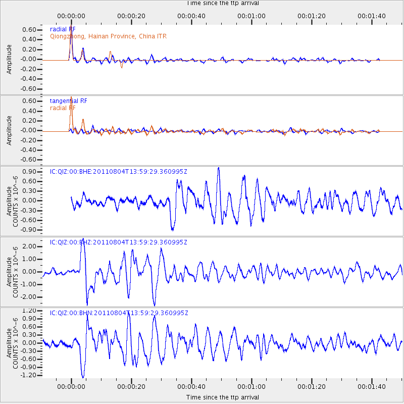
QIZ Qiongzhong, Hainan Province, China - Earthquake Result Viewer

| Earthquake location: |
Kuril Islands |
| Earthquake latitude/longitude: |
48.8/154.8 |
| Earthquake time(UTC): |
2011/08/04 (216) 13:51:34 GMT |
| Earthquake Depth: |
36 km |
| Earthquake Magnitude: |
6.0 MB, 5.8 MS, 6.1 MW, 6.0 MW |
| Earthquake Catalog/Contributor: |
WHDF/NEIC |
|
| Network: |
IC New China Digital Seismograph Network |
| Station: |
QIZ Qiongzhong, Hainan Province, China |
| Lat/Lon: |
19.03 N/109.84 E |
| Elevation: |
240 m |
|
| Distance: |
46.7 deg |
| Az: |
246.634 deg |
| Baz: |
39.88 deg |
| Ray Param: |
0.07040561 |
| Estimated Moho Depth: |
34.0 km |
| Estimated Crust Vp/Vs: |
1.70 |
| Assumed Crust Vp: |
6.182 km/s |
| Estimated Crust Vs: |
3.631 km/s |
| Estimated Crust Poisson's Ratio: |
0.24 |
|
| Radial Match: |
94.81758 % |
| Radial Bump: |
281 |
| Transverse Match: |
80.2788 % |
| Transverse Bump: |
400 |
| SOD ConfigId: |
408116 |
| Insert Time: |
2012-01-01 03:53:11.183 +0000 |
| GWidth: |
2.5 |
| Max Bumps: |
400 |
| Tol: |
0.001 |
|
Signal To Noise
| Channel | StoN | STA | LTA |
| IC:QIZ:00:BHZ:20110804T13:59:29.360995Z | 6.881198 | 1.1840245E-6 | 1.7206662E-7 |
| IC:QIZ:00:BHN:20110804T13:59:29.360995Z | 7.827826 | 5.6221035E-7 | 7.182203E-8 |
| IC:QIZ:00:BHE:20110804T13:59:29.360995Z | 3.7518787 | 4.0195548E-7 | 1.07134454E-7 |
| Arrivals |
| Ps | 4.1 SECOND |
| PpPs | 14 SECOND |
| PsPs/PpSs | 18 SECOND |


