You are here: Home > Network List > NM - Cooperative New Madrid Seismic Network Stations List
> Station SIUC Carbondale, IL > Earthquake Result Viewer
SIUC Carbondale, IL - Earthquake Result Viewer
| Earthquake location: |
Kuril Islands |
| Earthquake latitude/longitude: |
48.8/154.8 |
| Earthquake time(UTC): |
2011/08/04 (216) 13:51:34 GMT |
| Earthquake Depth: |
36 km |
| Earthquake Magnitude: |
6.0 MB, 5.8 MS, 6.1 MW, 6.0 MW |
| Earthquake Catalog/Contributor: |
WHDF/NEIC |
|
| Network: |
NM Cooperative New Madrid Seismic Network |
| Station: |
SIUC Carbondale, IL |
| Lat/Lon: |
37.71 N/89.22 W |
| Elevation: |
120 m |
|
| Distance: |
76.9 deg |
| Az: |
47.044 deg |
| Baz: |
322.425 deg |
| Ray Param: |
0.050660573 |
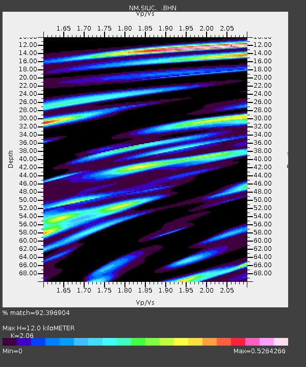
| Estimated Moho Depth: |
12.0 km |
| Estimated Crust Vp/Vs: |
2.06 |
| Assumed Crust Vp: |
6.444 km/s |
| Estimated Crust Vs: |
3.128 km/s |
| Estimated Crust Poisson's Ratio: |
0.35 |
|
| Radial Match: |
92.396904 % |
| Radial Bump: |
400 |
| Transverse Match: |
80.799225 % |
| Transverse Bump: |
400 |
| SOD ConfigId: |
408116 |
| Insert Time: |
2012-01-01 03:59:01.221 +0000 |
| GWidth: |
2.5 |
| Max Bumps: |
400 |
| Tol: |
0.001 |
|

Signal To Noise
| Channel | StoN | STA | LTA |
| NM:SIUC: :BHZ:20110804T14:02:51.844973Z | 22.332483 | 1.4131512E-6 | 6.327783E-8 |
| NM:SIUC: :BHN:20110804T14:02:51.844973Z | 4.0743675 | 6.5601586E-7 | 1.6101048E-7 |
| NM:SIUC: :BHE:20110804T14:02:51.844973Z | 2.9857035 | 3.4488056E-7 | 1.1551065E-7 |
| Arrivals |
| Ps | 2.0 SECOND |
| PpPs | 5.5 SECOND |
| PsPs/PpSs | 7.6 SECOND |


