You are here: Home > Network List > TA - USArray Transportable Network (new EarthScope stations) Stations List
> Station P56A Dayton Farm, Ripley, WV, USA > Earthquake Result Viewer
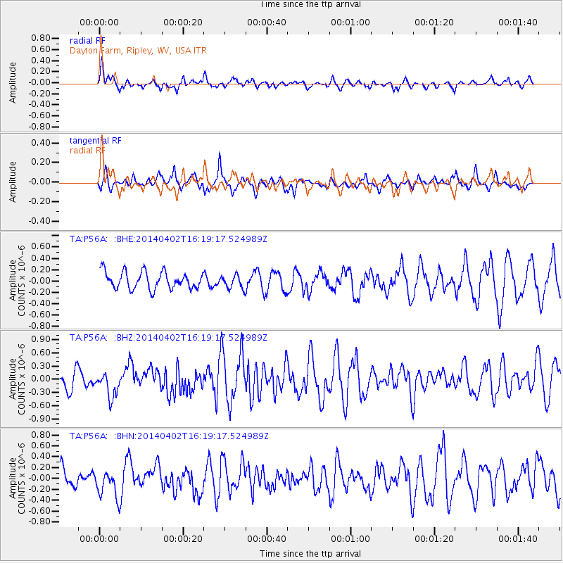
P56A Dayton Farm, Ripley, WV, USA - Earthquake Result Viewer
*The percent match for this event was below the threshold and hence no stack was calculated.
| Earthquake location: |
South Of Panama |
| Earthquake latitude/longitude: |
7.9/-82.3 |
| Earthquake time(UTC): |
2014/04/02 (092) 16:13:27 GMT |
| Earthquake Depth: |
32 km |
| Earthquake Magnitude: |
6.0 MWW, 5.9 MWB, 6.0 MWC |
| Earthquake Catalog/Contributor: |
NEIC PDE/NEIC COMCAT |
|
| Network: |
TA USArray Transportable Network (new EarthScope stations) |
| Station: |
P56A Dayton Farm, Ripley, WV, USA |
| Lat/Lon: |
39.50 N/78.84 W |
| Elevation: |
249 m |
|
| Distance: |
31.6 deg |
| Az: |
5.178 deg |
| Baz: |
186.636 deg |
| Ray Param: |
$rayparam |
*The percent match for this event was below the threshold and hence was not used in the summary stack. |
|
| Radial Match: |
62.534676 % |
| Radial Bump: |
378 |
| Transverse Match: |
77.713425 % |
| Transverse Bump: |
400 |
| SOD ConfigId: |
3390531 |
| Insert Time: |
2019-04-11 01:39:31.154 +0000 |
| GWidth: |
2.5 |
| Max Bumps: |
400 |
| Tol: |
0.001 |
|
Signal To Noise
| Channel | StoN | STA | LTA |
| TA:P56A: :BHZ:20140402T16:19:17.524989Z | 0.883179 | 2.845648E-7 | 3.2220512E-7 |
| TA:P56A: :BHN:20140402T16:19:17.524989Z | 1.4600588 | 2.6658105E-7 | 1.8258241E-7 |
| TA:P56A: :BHE:20140402T16:19:17.524989Z | 0.6764106 | 1.0187433E-7 | 1.5061019E-7 |
| Arrivals |
| Ps | |
| PpPs | |
| PsPs/PpSs | |


