You are here: Home > Network List > TA - USArray Transportable Network (new EarthScope stations) Stations List
> Station N32A Stulken Farm, Doniphan, NE, USA > Earthquake Result Viewer
N32A Stulken Farm, Doniphan, NE, USA - Earthquake Result Viewer

| Earthquake location: |
Kuril Islands |
| Earthquake latitude/longitude: |
48.8/154.8 |
| Earthquake time(UTC): |
2011/08/04 (216) 13:51:34 GMT |
| Earthquake Depth: |
36 km |
| Earthquake Magnitude: |
6.0 MB, 5.8 MS, 6.1 MW, 6.0 MW |
| Earthquake Catalog/Contributor: |
WHDF/NEIC |
|
| Network: |
TA USArray Transportable Network (new EarthScope stations) |
| Station: |
N32A Stulken Farm, Doniphan, NE, USA |
| Lat/Lon: |
40.76 N/98.30 W |
| Elevation: |
587 m |
|
| Distance: |
70.0 deg |
| Az: |
50.648 deg |
| Baz: |
317.727 deg |
| Ray Param: |
0.05521502 |
| Estimated Moho Depth: |
37.75 km |
| Estimated Crust Vp/Vs: |
1.99 |
| Assumed Crust Vp: |
6.53 km/s |
| Estimated Crust Vs: |
3.282 km/s |
| Estimated Crust Poisson's Ratio: |
0.33 |
|
| Radial Match: |
87.21068 % |
| Radial Bump: |
400 |
| Transverse Match: |
75.77634 % |
| Transverse Bump: |
400 |
| SOD ConfigId: |
408116 |
| Insert Time: |
2012-01-01 04:03:52.954 +0000 |
| GWidth: |
2.5 |
| Max Bumps: |
400 |
| Tol: |
0.001 |
|
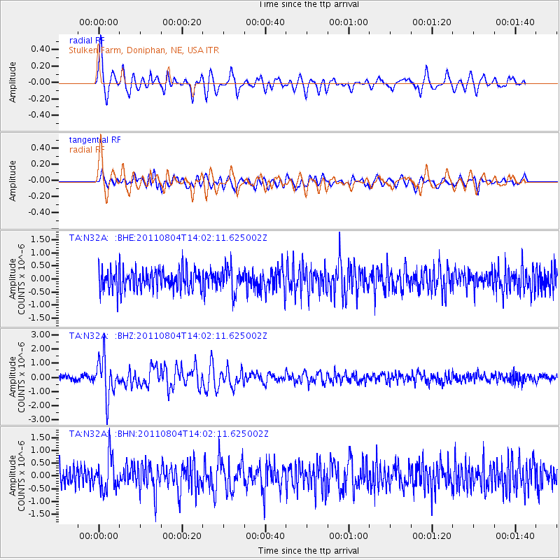
Signal To Noise
| Channel | StoN | STA | LTA |
| TA:N32A: :BHZ:20110804T14:02:11.625002Z | 7.795398 | 1.364821E-6 | 1.7508033E-7 |
| TA:N32A: :BHN:20110804T14:02:11.625002Z | 1.9065176 | 6.549317E-7 | 3.4352252E-7 |
| TA:N32A: :BHE:20110804T14:02:11.625002Z | 1.247908 | 4.78836E-7 | 3.8371098E-7 |
| Arrivals |
| Ps | 5.9 SECOND |
| PpPs | 17 SECOND |
| PsPs/PpSs | 23 SECOND |


