You are here: Home > Network List > TA - USArray Transportable Network (new EarthScope stations) Stations List
> Station L31A Butterfield Farm, Chambers, NE, USA > Earthquake Result Viewer
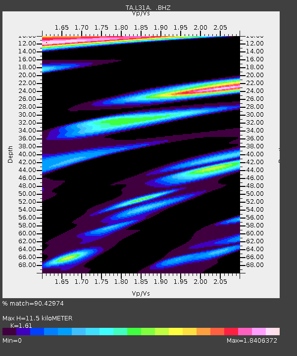
L31A Butterfield Farm, Chambers, NE, USA - Earthquake Result Viewer
| Earthquake location: |
Kuril Islands |
| Earthquake latitude/longitude: |
48.8/154.8 |
| Earthquake time(UTC): |
2011/08/04 (216) 13:51:34 GMT |
| Earthquake Depth: |
36 km |
| Earthquake Magnitude: |
6.0 MB, 5.8 MS, 6.1 MW, 6.0 MW |
| Earthquake Catalog/Contributor: |
WHDF/NEIC |
|
| Network: |
TA USArray Transportable Network (new EarthScope stations) |
| Station: |
L31A Butterfield Farm, Chambers, NE, USA |
| Lat/Lon: |
42.18 N/98.84 W |
| Elevation: |
670 m |
|
| Distance: |
68.7 deg |
| Az: |
49.949 deg |
| Baz: |
317.122 deg |
| Ray Param: |
0.05608367 |
| Estimated Moho Depth: |
11.5 km |
| Estimated Crust Vp/Vs: |
1.61 |
| Assumed Crust Vp: |
6.53 km/s |
| Estimated Crust Vs: |
4.056 km/s |
| Estimated Crust Poisson's Ratio: |
0.19 |
|
| Radial Match: |
90.42974 % |
| Radial Bump: |
344 |
| Transverse Match: |
79.76802 % |
| Transverse Bump: |
382 |
| SOD ConfigId: |
408116 |
| Insert Time: |
2012-01-01 04:04:04.542 +0000 |
| GWidth: |
2.5 |
| Max Bumps: |
400 |
| Tol: |
0.001 |
|

Signal To Noise
| Channel | StoN | STA | LTA |
| TA:L31A: :BHZ:20110804T14:02:03.500002Z | 31.765694 | 3.2403364E-6 | 1.0200742E-7 |
| TA:L31A: :BHN:20110804T14:02:03.500002Z | 2.6031926 | 7.2507135E-7 | 2.785316E-7 |
| TA:L31A: :BHE:20110804T14:02:03.500002Z | 4.6801586 | 1.0100013E-6 | 2.1580493E-7 |
| Arrivals |
| Ps | 1.1 SECOND |
| PpPs | 4.4 SECOND |
| PsPs/PpSs | 5.5 SECOND |


