You are here: Home > Network List > TA - USArray Transportable Network (new EarthScope stations) Stations List
> Station S32A Newby Ranch, Pratt, KS, USA > Earthquake Result Viewer
S32A Newby Ranch, Pratt, KS, USA - Earthquake Result Viewer
| Earthquake location: |
Kuril Islands |
| Earthquake latitude/longitude: |
48.8/154.8 |
| Earthquake time(UTC): |
2011/08/04 (216) 13:51:34 GMT |
| Earthquake Depth: |
36 km |
| Earthquake Magnitude: |
6.0 MB, 5.8 MS, 6.1 MW, 6.0 MW |
| Earthquake Catalog/Contributor: |
WHDF/NEIC |
|
| Network: |
TA USArray Transportable Network (new EarthScope stations) |
| Station: |
S32A Newby Ranch, Pratt, KS, USA |
| Lat/Lon: |
37.70 N/98.94 W |
| Elevation: |
558 m |
|
| Distance: |
71.9 deg |
| Az: |
53.206 deg |
| Baz: |
318.157 deg |
| Ray Param: |
0.053936362 |
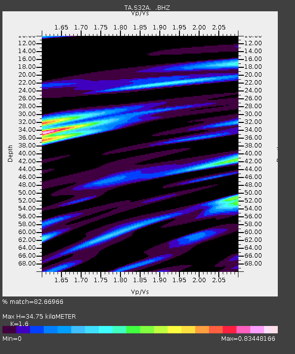
| Estimated Moho Depth: |
34.75 km |
| Estimated Crust Vp/Vs: |
1.60 |
| Assumed Crust Vp: |
6.426 km/s |
| Estimated Crust Vs: |
4.016 km/s |
| Estimated Crust Poisson's Ratio: |
0.18 |
|
| Radial Match: |
82.66966 % |
| Radial Bump: |
400 |
| Transverse Match: |
69.568634 % |
| Transverse Bump: |
400 |
| SOD ConfigId: |
408116 |
| Insert Time: |
2012-01-01 04:04:54.455 +0000 |
| GWidth: |
2.5 |
| Max Bumps: |
400 |
| Tol: |
0.001 |
|

Signal To Noise
| Channel | StoN | STA | LTA |
| TA:S32A: :BHZ:20110804T14:02:23.349978Z | 6.6541605 | 1.0150769E-6 | 1.5254771E-7 |
| TA:S32A: :BHN:20110804T14:02:23.349978Z | 2.4979901 | 4.2971232E-7 | 1.7202322E-7 |
| TA:S32A: :BHE:20110804T14:02:23.349978Z | 2.0329745 | 3.2484715E-7 | 1.597891E-7 |
| Arrivals |
| Ps | 3.4 SECOND |
| PpPs | 14 SECOND |
| PsPs/PpSs | 17 SECOND |


