You are here: Home > Network List > TA - USArray Transportable Network (new EarthScope stations) Stations List
> Station T33A Patterson Ranch, Waldron, KS, USA > Earthquake Result Viewer
T33A Patterson Ranch, Waldron, KS, USA - Earthquake Result Viewer

| Earthquake location: |
Kuril Islands |
| Earthquake latitude/longitude: |
48.8/154.8 |
| Earthquake time(UTC): |
2011/08/04 (216) 13:51:34 GMT |
| Earthquake Depth: |
36 km |
| Earthquake Magnitude: |
6.0 MB, 5.8 MS, 6.1 MW, 6.0 MW |
| Earthquake Catalog/Contributor: |
WHDF/NEIC |
|
| Network: |
TA USArray Transportable Network (new EarthScope stations) |
| Station: |
T33A Patterson Ranch, Waldron, KS, USA |
| Lat/Lon: |
37.08 N/98.24 W |
| Elevation: |
394 m |
|
| Distance: |
72.8 deg |
| Az: |
53.204 deg |
| Baz: |
318.575 deg |
| Ray Param: |
0.053389788 |
| Estimated Moho Depth: |
44.75 km |
| Estimated Crust Vp/Vs: |
1.84 |
| Assumed Crust Vp: |
6.426 km/s |
| Estimated Crust Vs: |
3.497 km/s |
| Estimated Crust Poisson's Ratio: |
0.29 |
|
| Radial Match: |
84.33929 % |
| Radial Bump: |
396 |
| Transverse Match: |
65.85656 % |
| Transverse Bump: |
400 |
| SOD ConfigId: |
408116 |
| Insert Time: |
2012-01-01 04:05:07.504 +0000 |
| GWidth: |
2.5 |
| Max Bumps: |
400 |
| Tol: |
0.001 |
|
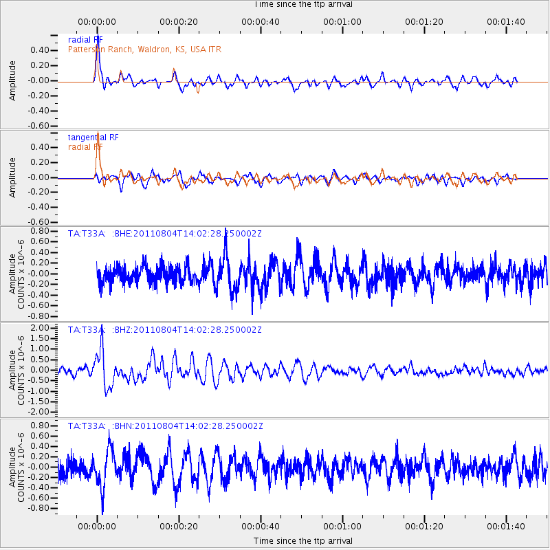
Signal To Noise
| Channel | StoN | STA | LTA |
| TA:T33A: :BHZ:20110804T14:02:28.250002Z | 6.6644893 | 8.946442E-7 | 1.3424048E-7 |
| TA:T33A: :BHN:20110804T14:02:28.250002Z | 2.4784167 | 3.5764467E-7 | 1.4430368E-7 |
| TA:T33A: :BHE:20110804T14:02:28.250002Z | 2.2041318 | 3.2859649E-7 | 1.4908204E-7 |
| Arrivals |
| Ps | 6.0 SECOND |
| PpPs | 19 SECOND |
| PsPs/PpSs | 25 SECOND |


