You are here: Home > Network List > TA - USArray Transportable Network (new EarthScope stations) Stations List
> Station N02D Trinity Center, CA, USA > Earthquake Result Viewer
N02D Trinity Center, CA, USA - Earthquake Result Viewer
| Earthquake location: |
Kuril Islands |
| Earthquake latitude/longitude: |
48.8/154.8 |
| Earthquake time(UTC): |
2011/08/04 (216) 13:51:34 GMT |
| Earthquake Depth: |
36 km |
| Earthquake Magnitude: |
6.0 MB, 5.8 MS, 6.1 MW, 6.0 MW |
| Earthquake Catalog/Contributor: |
WHDF/NEIC |
|
| Network: |
TA USArray Transportable Network (new EarthScope stations) |
| Station: |
N02D Trinity Center, CA, USA |
| Lat/Lon: |
40.97 N/122.71 W |
| Elevation: |
937 m |
|
| Distance: |
56.3 deg |
| Az: |
64.525 deg |
| Baz: |
308.019 deg |
| Ray Param: |
0.06418763 |
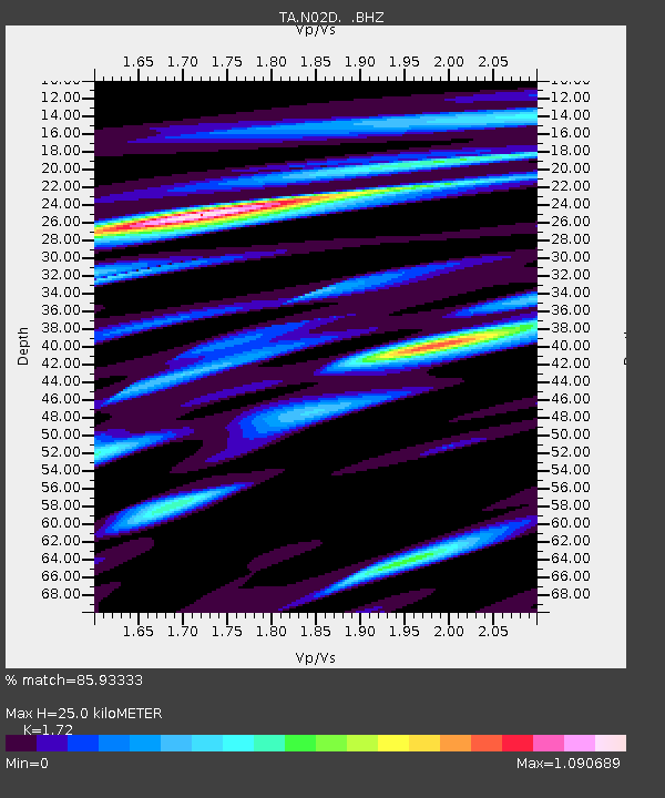
| Estimated Moho Depth: |
25.0 km |
| Estimated Crust Vp/Vs: |
1.72 |
| Assumed Crust Vp: |
6.566 km/s |
| Estimated Crust Vs: |
3.818 km/s |
| Estimated Crust Poisson's Ratio: |
0.24 |
|
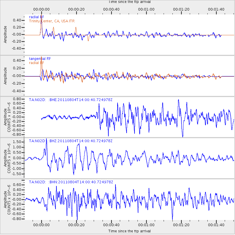
| Radial Match: |
85.93333 % |
| Radial Bump: |
400 |
| Transverse Match: |
82.245735 % |
| Transverse Bump: |
400 |
| SOD ConfigId: |
408116 |
| Insert Time: |
2012-01-01 04:07:15.279 +0000 |
| GWidth: |
2.5 |
| Max Bumps: |
400 |
| Tol: |
0.001 |
|
Signal To Noise
| Channel | StoN | STA | LTA |
| TA:N02D: :BHZ:20110804T14:00:40.724978Z | 9.00301 | 7.0805527E-7 | 7.86465E-8 |
| TA:N02D: :BHN:20110804T14:00:40.724978Z | 3.5701964 | 2.2459866E-7 | 6.290933E-8 |
| TA:N02D: :BHE:20110804T14:00:40.724978Z | 4.8519406 | 2.433081E-7 | 5.0146557E-8 |
| Arrivals |
| Ps | 2.9 SECOND |
| PpPs | 9.8 SECOND |
| PsPs/PpSs | 13 SECOND |


