You are here: Home > Network List > TA - USArray Transportable Network (new EarthScope stations) Stations List
> Station 433A Art, TX, USA > Earthquake Result Viewer
433A Art, TX, USA - Earthquake Result Viewer

| Earthquake location: |
Kuril Islands |
| Earthquake latitude/longitude: |
48.8/154.8 |
| Earthquake time(UTC): |
2011/08/04 (216) 13:51:34 GMT |
| Earthquake Depth: |
36 km |
| Earthquake Magnitude: |
6.0 MB, 5.8 MS, 6.1 MW, 6.0 MW |
| Earthquake Catalog/Contributor: |
WHDF/NEIC |
|
| Network: |
TA USArray Transportable Network (new EarthScope stations) |
| Station: |
433A Art, TX, USA |
| Lat/Lon: |
30.75 N/99.09 W |
| Elevation: |
447 m |
|
| Distance: |
77.1 deg |
| Az: |
58.045 deg |
| Baz: |
319.365 deg |
| Ray Param: |
0.05051921 |
| Estimated Moho Depth: |
33.0 km |
| Estimated Crust Vp/Vs: |
1.91 |
| Assumed Crust Vp: |
6.498 km/s |
| Estimated Crust Vs: |
3.406 km/s |
| Estimated Crust Poisson's Ratio: |
0.31 |
|
| Radial Match: |
93.15568 % |
| Radial Bump: |
400 |
| Transverse Match: |
83.80518 % |
| Transverse Bump: |
400 |
| SOD ConfigId: |
408116 |
| Insert Time: |
2012-01-01 04:07:56.349 +0000 |
| GWidth: |
2.5 |
| Max Bumps: |
400 |
| Tol: |
0.001 |
|
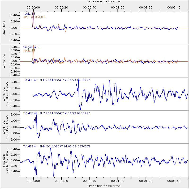
Signal To Noise
| Channel | StoN | STA | LTA |
| TA:433A: :BHZ:20110804T14:02:53.025027Z | 19.69278 | 1.1418364E-6 | 5.7982486E-8 |
| TA:433A: :BHN:20110804T14:02:53.025027Z | 7.1131983 | 2.6305497E-7 | 3.6981252E-8 |
| TA:433A: :BHE:20110804T14:02:53.025027Z | 5.4181314 | 2.9219257E-7 | 5.392866E-8 |
| Arrivals |
| Ps | 4.7 SECOND |
| PpPs | 14 SECOND |
| PsPs/PpSs | 19 SECOND |


