You are here: Home > Network List > TA - USArray Transportable Network (new EarthScope stations) Stations List
> Station X37A Clayton, OK, USA > Earthquake Result Viewer
X37A Clayton, OK, USA - Earthquake Result Viewer
| Earthquake location: |
Kuril Islands |
| Earthquake latitude/longitude: |
48.8/154.8 |
| Earthquake time(UTC): |
2011/08/04 (216) 13:51:34 GMT |
| Earthquake Depth: |
36 km |
| Earthquake Magnitude: |
6.0 MB, 5.8 MS, 6.1 MW, 6.0 MW |
| Earthquake Catalog/Contributor: |
WHDF/NEIC |
|
| Network: |
TA USArray Transportable Network (new EarthScope stations) |
| Station: |
X37A Clayton, OK, USA |
| Lat/Lon: |
34.59 N/95.37 W |
| Elevation: |
207 m |
|
| Distance: |
76.2 deg |
| Az: |
53.045 deg |
| Baz: |
320.208 deg |
| Ray Param: |
0.051117726 |
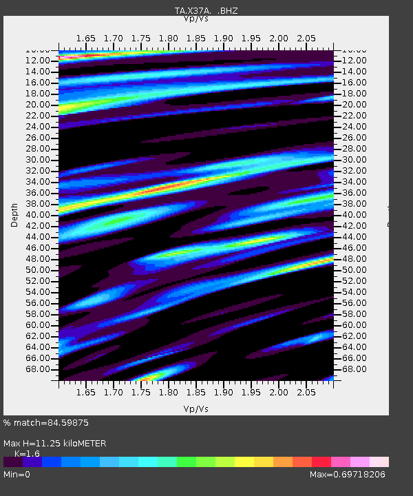
| Estimated Moho Depth: |
11.25 km |
| Estimated Crust Vp/Vs: |
1.60 |
| Assumed Crust Vp: |
6.498 km/s |
| Estimated Crust Vs: |
4.061 km/s |
| Estimated Crust Poisson's Ratio: |
0.18 |
|
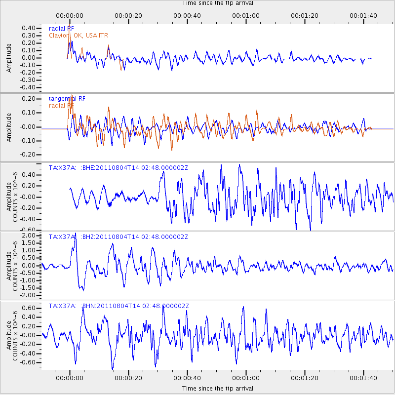
| Radial Match: |
84.59875 % |
| Radial Bump: |
400 |
| Transverse Match: |
76.36523 % |
| Transverse Bump: |
400 |
| SOD ConfigId: |
408116 |
| Insert Time: |
2012-01-01 04:13:45.077 +0000 |
| GWidth: |
2.5 |
| Max Bumps: |
400 |
| Tol: |
0.001 |
|
Signal To Noise
| Channel | StoN | STA | LTA |
| TA:X37A: :BHZ:20110804T14:02:48.000002Z | 10.909795 | 1.1671783E-6 | 1.0698445E-7 |
| TA:X37A: :BHN:20110804T14:02:48.000002Z | 3.3535583 | 3.112213E-7 | 9.2803305E-8 |
| TA:X37A: :BHE:20110804T14:02:48.000002Z | 2.7909682 | 2.613423E-7 | 9.363859E-8 |
| Arrivals |
| Ps | 1.1 SECOND |
| PpPs | 4.3 SECOND |
| PsPs/PpSs | 5.4 SECOND |


