You are here: Home > Network List > TA - USArray Transportable Network (new EarthScope stations) Stations List
> Station W38A Poteau, OK, USA > Earthquake Result Viewer
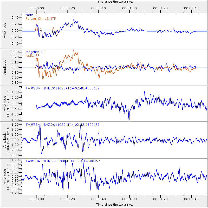
W38A Poteau, OK, USA - Earthquake Result Viewer
*The percent match for this event was below the threshold and hence no stack was calculated.
| Earthquake location: |
Kuril Islands |
| Earthquake latitude/longitude: |
48.8/154.8 |
| Earthquake time(UTC): |
2011/08/04 (216) 13:51:34 GMT |
| Earthquake Depth: |
36 km |
| Earthquake Magnitude: |
6.0 MB, 5.8 MS, 6.1 MW, 6.0 MW |
| Earthquake Catalog/Contributor: |
WHDF/NEIC |
|
| Network: |
TA USArray Transportable Network (new EarthScope stations) |
| Station: |
W38A Poteau, OK, USA |
| Lat/Lon: |
35.07 N/94.52 W |
| Elevation: |
169 m |
|
| Distance: |
76.3 deg |
| Az: |
52.173 deg |
| Baz: |
320.485 deg |
| Ray Param: |
$rayparam |
*The percent match for this event was below the threshold and hence was not used in the summary stack. |
|
| Radial Match: |
63.088913 % |
| Radial Bump: |
400 |
| Transverse Match: |
69.11351 % |
| Transverse Bump: |
400 |
| SOD ConfigId: |
408116 |
| Insert Time: |
2012-01-01 04:13:56.549 +0000 |
| GWidth: |
2.5 |
| Max Bumps: |
400 |
| Tol: |
0.001 |
|
Signal To Noise
| Channel | StoN | STA | LTA |
| TA:W38A: :BHZ:20110804T14:02:48.450015Z | 9.624833 | 1.564119E-6 | 1.6250868E-7 |
| TA:W38A: :BHN:20110804T14:02:48.450015Z | 2.9709413 | 4.0506836E-7 | 1.3634344E-7 |
| TA:W38A: :BHE:20110804T14:02:48.450015Z | 1.9151293 | 3.1943225E-7 | 1.667941E-7 |
| Arrivals |
| Ps | |
| PpPs | |
| PsPs/PpSs | |


