You are here: Home > Network List > TA - USArray Transportable Network (new EarthScope stations) Stations List
> Station M33A Taylor Creek Farms, Clarkson, NE, USA > Earthquake Result Viewer
M33A Taylor Creek Farms, Clarkson, NE, USA - Earthquake Result Viewer
| Earthquake location: |
Kuril Islands |
| Earthquake latitude/longitude: |
48.8/154.8 |
| Earthquake time(UTC): |
2011/08/04 (216) 13:51:34 GMT |
| Earthquake Depth: |
36 km |
| Earthquake Magnitude: |
6.0 MB, 5.8 MS, 6.1 MW, 6.0 MW |
| Earthquake Catalog/Contributor: |
WHDF/NEIC |
|
| Network: |
TA USArray Transportable Network (new EarthScope stations) |
| Station: |
M33A Taylor Creek Farms, Clarkson, NE, USA |
| Lat/Lon: |
41.57 N/97.19 W |
| Elevation: |
503 m |
|
| Distance: |
70.0 deg |
| Az: |
49.415 deg |
| Baz: |
318.026 deg |
| Ray Param: |
0.055242818 |
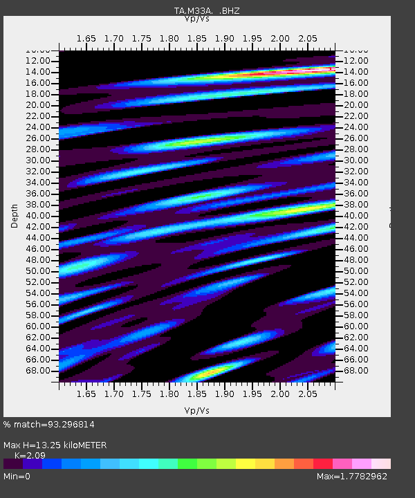
| Estimated Moho Depth: |
13.25 km |
| Estimated Crust Vp/Vs: |
2.09 |
| Assumed Crust Vp: |
6.498 km/s |
| Estimated Crust Vs: |
3.109 km/s |
| Estimated Crust Poisson's Ratio: |
0.35 |
|
| Radial Match: |
93.296814 % |
| Radial Bump: |
400 |
| Transverse Match: |
86.7521 % |
| Transverse Bump: |
400 |
| SOD ConfigId: |
408116 |
| Insert Time: |
2012-01-01 04:18:40.889 +0000 |
| GWidth: |
2.5 |
| Max Bumps: |
400 |
| Tol: |
0.001 |
|
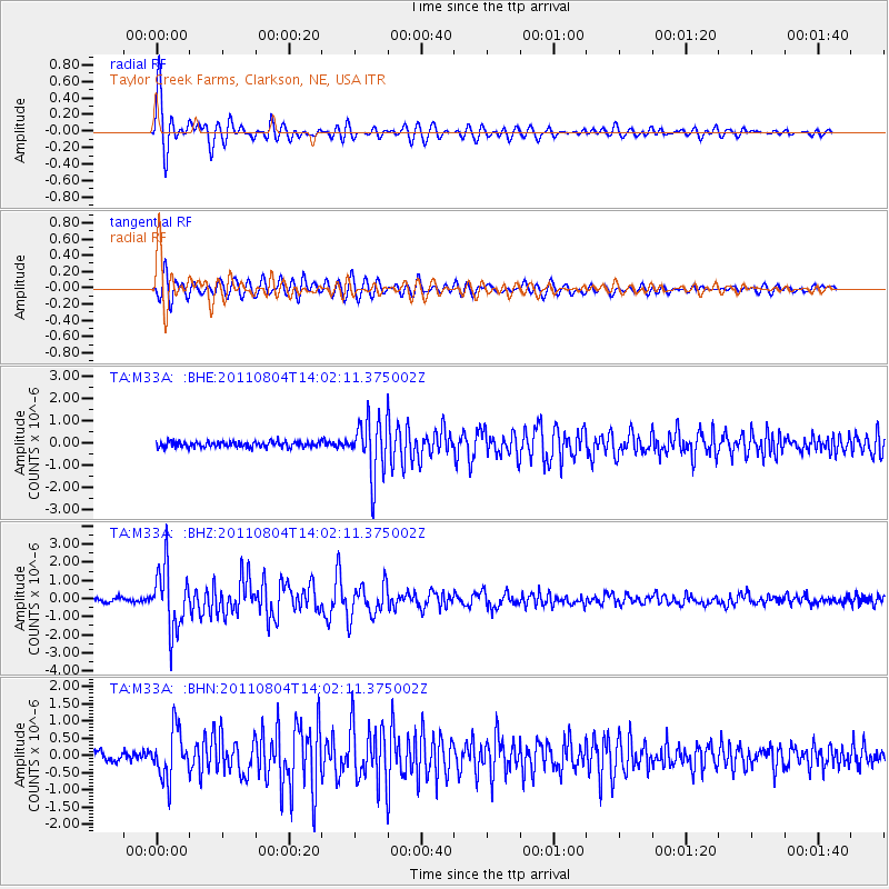
Signal To Noise
| Channel | StoN | STA | LTA |
| TA:M33A: :BHZ:20110804T14:02:11.375002Z | 18.437727 | 1.7059288E-6 | 9.2523806E-8 |
| TA:M33A: :BHN:20110804T14:02:11.375002Z | 5.069819 | 7.007639E-7 | 1.3822267E-7 |
| TA:M33A: :BHE:20110804T14:02:11.375002Z | 9.983817 | 1.2713906E-6 | 1.2734515E-7 |
| Arrivals |
| Ps | 2.3 SECOND |
| PpPs | 6.1 SECOND |
| PsPs/PpSs | 8.4 SECOND |


