You are here: Home > Network List > TA - USArray Transportable Network (new EarthScope stations) Stations List
> Station K32A Verdigre, NE, USA > Earthquake Result Viewer
K32A Verdigre, NE, USA - Earthquake Result Viewer
| Earthquake location: |
Kuril Islands |
| Earthquake latitude/longitude: |
48.8/154.8 |
| Earthquake time(UTC): |
2011/08/04 (216) 13:51:34 GMT |
| Earthquake Depth: |
36 km |
| Earthquake Magnitude: |
6.0 MB, 5.8 MS, 6.1 MW, 6.0 MW |
| Earthquake Catalog/Contributor: |
WHDF/NEIC |
|
| Network: |
TA USArray Transportable Network (new EarthScope stations) |
| Station: |
K32A Verdigre, NE, USA |
| Lat/Lon: |
42.66 N/97.97 W |
| Elevation: |
512 m |
|
| Distance: |
68.8 deg |
| Az: |
49.091 deg |
| Baz: |
317.393 deg |
| Ray Param: |
0.05603111 |
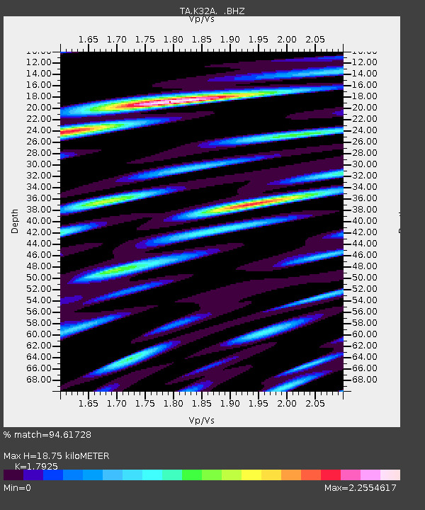
| Estimated Moho Depth: |
18.75 km |
| Estimated Crust Vp/Vs: |
1.79 |
| Assumed Crust Vp: |
6.498 km/s |
| Estimated Crust Vs: |
3.625 km/s |
| Estimated Crust Poisson's Ratio: |
0.27 |
|
| Radial Match: |
94.61728 % |
| Radial Bump: |
400 |
| Transverse Match: |
93.1583 % |
| Transverse Bump: |
400 |
| SOD ConfigId: |
408116 |
| Insert Time: |
2012-01-01 04:20:04.265 +0000 |
| GWidth: |
2.5 |
| Max Bumps: |
400 |
| Tol: |
0.001 |
|

Signal To Noise
| Channel | StoN | STA | LTA |
| TA:K32A: :BHZ:20110804T14:02:04.000002Z | 14.818471 | 1.430711E-6 | 9.654917E-8 |
| TA:K32A: :BHN:20110804T14:02:04.000002Z | 7.0159883 | 1.0917946E-6 | 1.5561524E-7 |
| TA:K32A: :BHE:20110804T14:02:04.000002Z | 4.7636766 | 8.389112E-7 | 1.7610581E-7 |
| Arrivals |
| Ps | 2.4 SECOND |
| PpPs | 7.8 SECOND |
| PsPs/PpSs | 10 SECOND |


