You are here: Home > Network List > TA - USArray Transportable Network (new EarthScope stations) Stations List
> Station J32A Parkston, SD, USA > Earthquake Result Viewer
J32A Parkston, SD, USA - Earthquake Result Viewer
| Earthquake location: |
Kuril Islands |
| Earthquake latitude/longitude: |
48.8/154.8 |
| Earthquake time(UTC): |
2011/08/04 (216) 13:51:34 GMT |
| Earthquake Depth: |
36 km |
| Earthquake Magnitude: |
6.0 MB, 5.8 MS, 6.1 MW, 6.0 MW |
| Earthquake Catalog/Contributor: |
WHDF/NEIC |
|
| Network: |
TA USArray Transportable Network (new EarthScope stations) |
| Station: |
J32A Parkston, SD, USA |
| Lat/Lon: |
43.37 N/97.85 W |
| Elevation: |
399 m |
|
| Distance: |
68.3 deg |
| Az: |
48.5 deg |
| Baz: |
317.261 deg |
| Ray Param: |
0.056332614 |
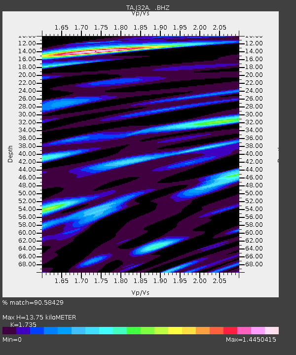
| Estimated Moho Depth: |
13.75 km |
| Estimated Crust Vp/Vs: |
1.74 |
| Assumed Crust Vp: |
6.498 km/s |
| Estimated Crust Vs: |
3.745 km/s |
| Estimated Crust Poisson's Ratio: |
0.25 |
|
| Radial Match: |
90.58429 % |
| Radial Bump: |
400 |
| Transverse Match: |
83.87603 % |
| Transverse Bump: |
400 |
| SOD ConfigId: |
408116 |
| Insert Time: |
2012-01-01 04:20:19.442 +0000 |
| GWidth: |
2.5 |
| Max Bumps: |
400 |
| Tol: |
0.001 |
|

Signal To Noise
| Channel | StoN | STA | LTA |
| TA:J32A: :BHZ:20110804T14:02:01.150027Z | 16.46265 | 1.3001297E-6 | 7.897451E-8 |
| TA:J32A: :BHN:20110804T14:02:01.150027Z | 8.635761 | 6.2310437E-7 | 7.215396E-8 |
| TA:J32A: :BHE:20110804T14:02:01.150027Z | 14.398265 | 9.2021986E-7 | 6.3911855E-8 |
| Arrivals |
| Ps | 1.6 SECOND |
| PpPs | 5.6 SECOND |
| PsPs/PpSs | 7.2 SECOND |


