You are here: Home > Network List > TA - USArray Transportable Network (new EarthScope stations) Stations List
> Station I34A Hadley, MN, USA > Earthquake Result Viewer
I34A Hadley, MN, USA - Earthquake Result Viewer

| Earthquake location: |
Kuril Islands |
| Earthquake latitude/longitude: |
48.8/154.8 |
| Earthquake time(UTC): |
2011/08/04 (216) 13:51:34 GMT |
| Earthquake Depth: |
36 km |
| Earthquake Magnitude: |
6.0 MB, 5.8 MS, 6.1 MW, 6.0 MW |
| Earthquake Catalog/Contributor: |
WHDF/NEIC |
|
| Network: |
TA USArray Transportable Network (new EarthScope stations) |
| Station: |
I34A Hadley, MN, USA |
| Lat/Lon: |
44.04 N/95.86 W |
| Elevation: |
509 m |
|
| Distance: |
68.8 deg |
| Az: |
46.873 deg |
| Baz: |
318.035 deg |
| Ray Param: |
0.05602015 |
| Estimated Moho Depth: |
48.25 km |
| Estimated Crust Vp/Vs: |
1.80 |
| Assumed Crust Vp: |
6.571 km/s |
| Estimated Crust Vs: |
3.65 km/s |
| Estimated Crust Poisson's Ratio: |
0.28 |
|
| Radial Match: |
94.471985 % |
| Radial Bump: |
400 |
| Transverse Match: |
81.41989 % |
| Transverse Bump: |
400 |
| SOD ConfigId: |
408116 |
| Insert Time: |
2012-01-01 04:21:08.976 +0000 |
| GWidth: |
2.5 |
| Max Bumps: |
400 |
| Tol: |
0.001 |
|
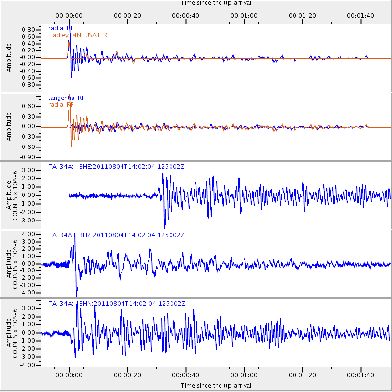
Signal To Noise
| Channel | StoN | STA | LTA |
| TA:I34A: :BHZ:20110804T14:02:04.125002Z | 9.566702 | 1.8748955E-6 | 1.9598137E-7 |
| TA:I34A: :BHN:20110804T14:02:04.125002Z | 11.200904 | 1.6544022E-6 | 1.4770256E-7 |
| TA:I34A: :BHE:20110804T14:02:04.125002Z | 11.834276 | 1.568034E-6 | 1.3249937E-7 |
| Arrivals |
| Ps | 6.1 SECOND |
| PpPs | 20 SECOND |
| PsPs/PpSs | 26 SECOND |


