You are here: Home > Network List > TA - USArray Transportable Network (new EarthScope stations) Stations List
> Station R54A Victor, WV, USA > Earthquake Result Viewer
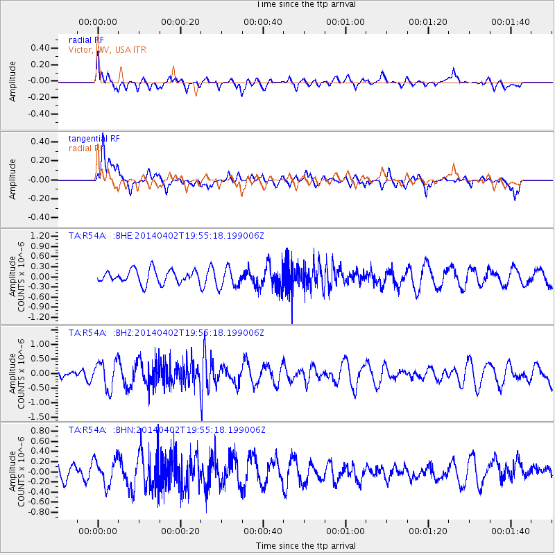
R54A Victor, WV, USA - Earthquake Result Viewer
*The percent match for this event was below the threshold and hence no stack was calculated.
| Earthquake location: |
Near Coast Of Northern Chile |
| Earthquake latitude/longitude: |
-20.4/-70.6 |
| Earthquake time(UTC): |
2014/04/02 (092) 19:45:49 GMT |
| Earthquake Depth: |
17 km |
| Earthquake Magnitude: |
5.3 MW |
| Earthquake Catalog/Contributor: |
ISC/ISC |
|
| Network: |
TA USArray Transportable Network (new EarthScope stations) |
| Station: |
R54A Victor, WV, USA |
| Lat/Lon: |
38.18 N/80.99 W |
| Elevation: |
512 m |
|
| Distance: |
59.1 deg |
| Az: |
350.439 deg |
| Baz: |
168.599 deg |
| Ray Param: |
$rayparam |
*The percent match for this event was below the threshold and hence was not used in the summary stack. |
|
| Radial Match: |
38.92965 % |
| Radial Bump: |
400 |
| Transverse Match: |
59.546535 % |
| Transverse Bump: |
400 |
| SOD ConfigId: |
3390531 |
| Insert Time: |
2019-04-11 01:46:05.081 +0000 |
| GWidth: |
2.5 |
| Max Bumps: |
400 |
| Tol: |
0.001 |
|
Signal To Noise
| Channel | StoN | STA | LTA |
| TA:R54A: :BHZ:20140402T19:55:18.199006Z | 2.7399747 | 4.9433174E-7 | 1.8041472E-7 |
| TA:R54A: :BHN:20140402T19:55:18.199006Z | 1.8537663 | 2.6165873E-7 | 1.411498E-7 |
| TA:R54A: :BHE:20140402T19:55:18.199006Z | 1.5164899 | 2.9485918E-7 | 1.944353E-7 |
| Arrivals |
| Ps | |
| PpPs | |
| PsPs/PpSs | |


