You are here: Home > Network List > TA - USArray Transportable Network (new EarthScope stations) Stations List
> Station E32A Braaten, Kindred, ND, USA > Earthquake Result Viewer
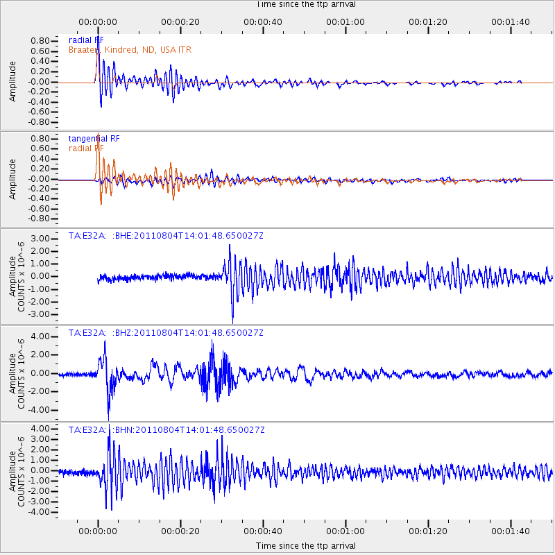
E32A Braaten, Kindred, ND, USA - Earthquake Result Viewer

| Earthquake location: |
Kuril Islands |
| Earthquake latitude/longitude: |
48.8/154.8 |
| Earthquake time(UTC): |
2011/08/04 (216) 13:51:34 GMT |
| Earthquake Depth: |
36 km |
| Earthquake Magnitude: |
6.0 MB, 5.8 MS, 6.1 MW, 6.0 MW |
| Earthquake Catalog/Contributor: |
WHDF/NEIC |
|
| Network: |
TA USArray Transportable Network (new EarthScope stations) |
| Station: |
E32A Braaten, Kindred, ND, USA |
| Lat/Lon: |
46.59 N/97.07 W |
| Elevation: |
297 m |
|
| Distance: |
66.3 deg |
| Az: |
45.682 deg |
| Baz: |
316.722 deg |
| Ray Param: |
0.057629958 |
| Estimated Moho Depth: |
35.5 km |
| Estimated Crust Vp/Vs: |
1.73 |
| Assumed Crust Vp: |
6.498 km/s |
| Estimated Crust Vs: |
3.767 km/s |
| Estimated Crust Poisson's Ratio: |
0.25 |
|
| Radial Match: |
83.65359 % |
| Radial Bump: |
400 |
| Transverse Match: |
66.75417 % |
| Transverse Bump: |
400 |
| SOD ConfigId: |
408116 |
| Insert Time: |
2012-01-01 04:23:44.618 +0000 |
| GWidth: |
2.5 |
| Max Bumps: |
400 |
| Tol: |
0.001 |
|
Signal To Noise
| Channel | StoN | STA | LTA |
| TA:E32A: :BHZ:20110804T14:01:48.650027Z | 13.785425 | 1.7076688E-6 | 1.2387495E-7 |
| TA:E32A: :BHN:20110804T14:01:48.650027Z | 10.130843 | 1.6577733E-6 | 1.6363626E-7 |
| TA:E32A: :BHE:20110804T14:01:48.650027Z | 7.565547 | 1.2478578E-6 | 1.6493952E-7 |
| Arrivals |
| Ps | 4.1 SECOND |
| PpPs | 14 SECOND |
| PsPs/PpSs | 18 SECOND |


