You are here: Home > Network List > TA - USArray Transportable Network (new EarthScope stations) Stations List
> Station E33A Westby DABS, Erhard, MN, USA > Earthquake Result Viewer
E33A Westby DABS, Erhard, MN, USA - Earthquake Result Viewer

| Earthquake location: |
Kuril Islands |
| Earthquake latitude/longitude: |
48.8/154.8 |
| Earthquake time(UTC): |
2011/08/04 (216) 13:51:34 GMT |
| Earthquake Depth: |
36 km |
| Earthquake Magnitude: |
6.0 MB, 5.8 MS, 6.1 MW, 6.0 MW |
| Earthquake Catalog/Contributor: |
WHDF/NEIC |
|
| Network: |
TA USArray Transportable Network (new EarthScope stations) |
| Station: |
E33A Westby DABS, Erhard, MN, USA |
| Lat/Lon: |
46.50 N/96.01 W |
| Elevation: |
428 m |
|
| Distance: |
66.9 deg |
| Az: |
45.163 deg |
| Baz: |
317.286 deg |
| Ray Param: |
0.05725387 |
| Estimated Moho Depth: |
35.0 km |
| Estimated Crust Vp/Vs: |
1.82 |
| Assumed Crust Vp: |
6.498 km/s |
| Estimated Crust Vs: |
3.575 km/s |
| Estimated Crust Poisson's Ratio: |
0.28 |
|
| Radial Match: |
91.22318 % |
| Radial Bump: |
400 |
| Transverse Match: |
74.04473 % |
| Transverse Bump: |
400 |
| SOD ConfigId: |
408116 |
| Insert Time: |
2012-01-01 04:24:45.530 +0000 |
| GWidth: |
2.5 |
| Max Bumps: |
400 |
| Tol: |
0.001 |
|
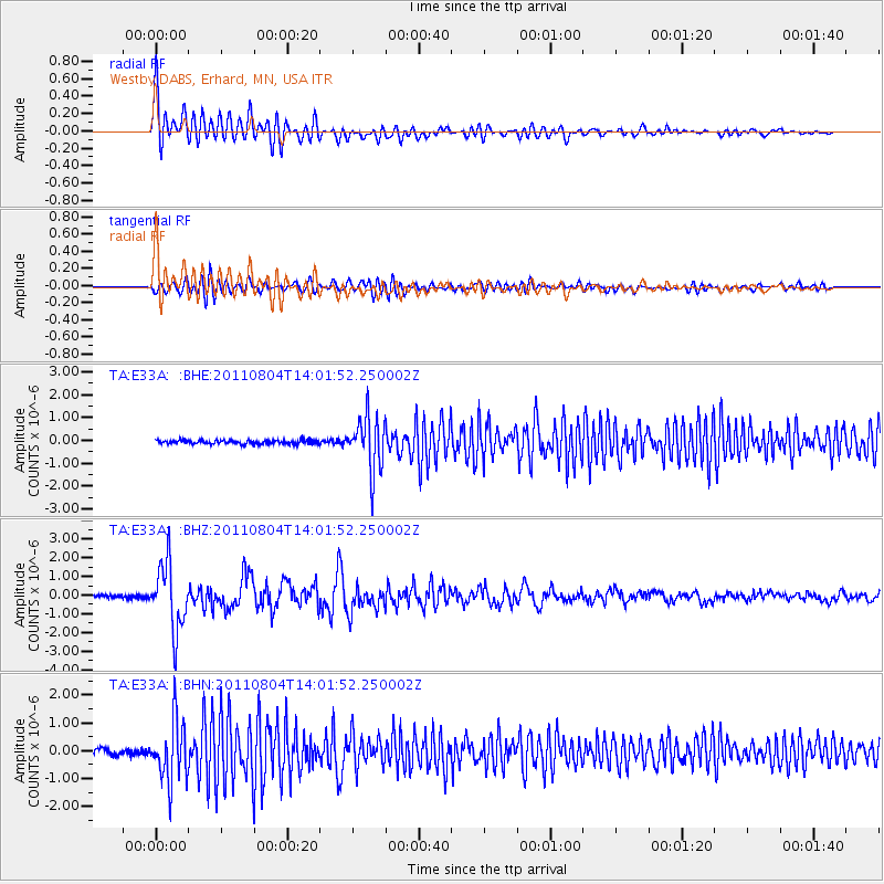
Signal To Noise
| Channel | StoN | STA | LTA |
| TA:E33A: :BHZ:20110804T14:01:52.250002Z | 22.709635 | 1.7504409E-6 | 7.7079214E-8 |
| TA:E33A: :BHN:20110804T14:01:52.250002Z | 10.034388 | 1.0777095E-6 | 1.07401625E-7 |
| TA:E33A: :BHE:20110804T14:01:52.250002Z | 14.230783 | 1.1725629E-6 | 8.239623E-8 |
| Arrivals |
| Ps | 4.6 SECOND |
| PpPs | 15 SECOND |
| PsPs/PpSs | 19 SECOND |


