You are here: Home > Network List > TA - USArray Transportable Network (new EarthScope stations) Stations List
> Station B05D Stanwood, WA, USA > Earthquake Result Viewer
B05D Stanwood, WA, USA - Earthquake Result Viewer
| Earthquake location: |
Kuril Islands |
| Earthquake latitude/longitude: |
48.8/154.8 |
| Earthquake time(UTC): |
2011/08/04 (216) 13:51:34 GMT |
| Earthquake Depth: |
36 km |
| Earthquake Magnitude: |
6.0 MB, 5.8 MS, 6.1 MW, 6.0 MW |
| Earthquake Catalog/Contributor: |
WHDF/NEIC |
|
| Network: |
TA USArray Transportable Network (new EarthScope stations) |
| Station: |
B05D Stanwood, WA, USA |
| Lat/Lon: |
48.26 N/122.10 W |
| Elevation: |
153 m |
|
| Distance: |
52.3 deg |
| Az: |
56.949 deg |
| Baz: |
304.017 deg |
| Ray Param: |
0.06676332 |
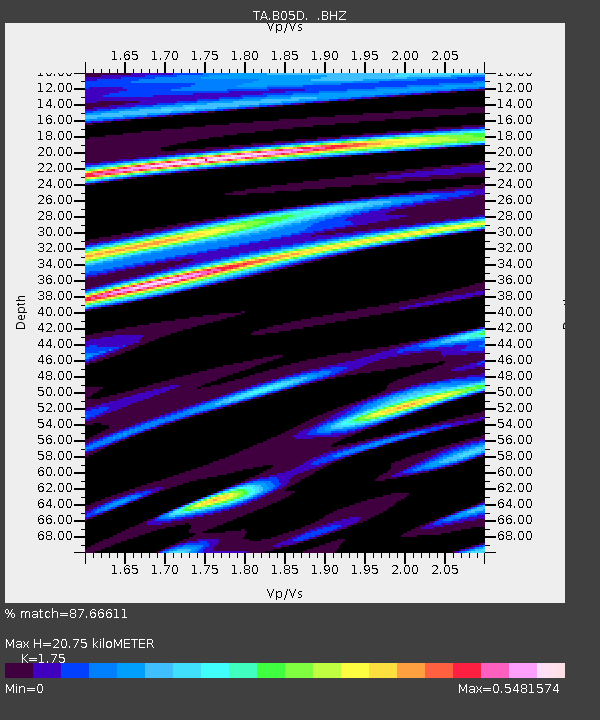
| Estimated Moho Depth: |
20.75 km |
| Estimated Crust Vp/Vs: |
1.75 |
| Assumed Crust Vp: |
6.566 km/s |
| Estimated Crust Vs: |
3.752 km/s |
| Estimated Crust Poisson's Ratio: |
0.26 |
|
| Radial Match: |
87.66611 % |
| Radial Bump: |
400 |
| Transverse Match: |
82.87032 % |
| Transverse Bump: |
400 |
| SOD ConfigId: |
408116 |
| Insert Time: |
2012-01-01 04:25:10.936 +0000 |
| GWidth: |
2.5 |
| Max Bumps: |
400 |
| Tol: |
0.001 |
|

Signal To Noise
| Channel | StoN | STA | LTA |
| TA:B05D: :BHZ:20110804T14:00:12.125002Z | 14.335605 | 7.8222683E-7 | 5.456532E-8 |
| TA:B05D: :BHN:20110804T14:00:12.125002Z | 3.3310776 | 2.3604566E-7 | 7.086165E-8 |
| TA:B05D: :BHE:20110804T14:00:12.125002Z | 6.8785915 | 3.4878252E-7 | 5.0705513E-8 |
| Arrivals |
| Ps | 2.5 SECOND |
| PpPs | 8.2 SECOND |
| PsPs/PpSs | 11 SECOND |


