You are here: Home > Network List > TA - USArray Transportable Network (new EarthScope stations) Stations List
> Station D36A Goodland, MN, USA > Earthquake Result Viewer
D36A Goodland, MN, USA - Earthquake Result Viewer
| Earthquake location: |
Kuril Islands |
| Earthquake latitude/longitude: |
48.8/154.8 |
| Earthquake time(UTC): |
2011/08/04 (216) 13:51:34 GMT |
| Earthquake Depth: |
36 km |
| Earthquake Magnitude: |
6.0 MB, 5.8 MS, 6.1 MW, 6.0 MW |
| Earthquake Catalog/Contributor: |
WHDF/NEIC |
|
| Network: |
TA USArray Transportable Network (new EarthScope stations) |
| Station: |
D36A Goodland, MN, USA |
| Lat/Lon: |
47.18 N/93.16 W |
| Elevation: |
434 m |
|
| Distance: |
67.7 deg |
| Az: |
43.105 deg |
| Baz: |
318.558 deg |
| Ray Param: |
0.05672742 |
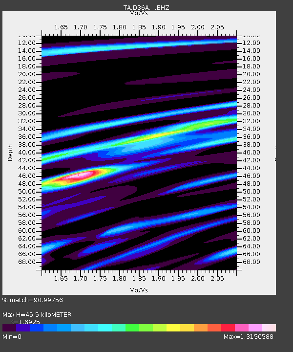
| Estimated Moho Depth: |
45.5 km |
| Estimated Crust Vp/Vs: |
1.69 |
| Assumed Crust Vp: |
6.571 km/s |
| Estimated Crust Vs: |
3.882 km/s |
| Estimated Crust Poisson's Ratio: |
0.23 |
|
| Radial Match: |
90.99756 % |
| Radial Bump: |
400 |
| Transverse Match: |
76.98798 % |
| Transverse Bump: |
400 |
| SOD ConfigId: |
408116 |
| Insert Time: |
2012-01-01 04:26:51.006 +0000 |
| GWidth: |
2.5 |
| Max Bumps: |
400 |
| Tol: |
0.001 |
|
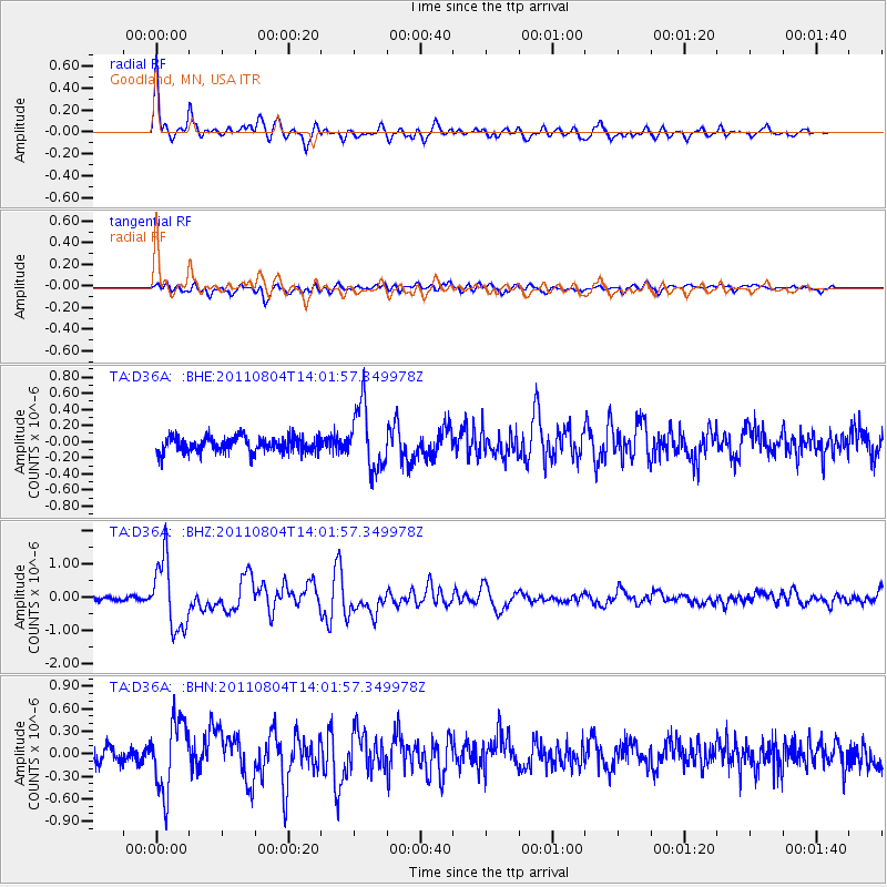
Signal To Noise
| Channel | StoN | STA | LTA |
| TA:D36A: :BHZ:20110804T14:01:57.349978Z | 12.035086 | 1.0355566E-6 | 8.60448E-8 |
| TA:D36A: :BHN:20110804T14:01:57.349978Z | 5.762213 | 4.66875E-7 | 8.102356E-8 |
| TA:D36A: :BHE:20110804T14:01:57.349978Z | 4.166183 | 3.874586E-7 | 9.3000864E-8 |
| Arrivals |
| Ps | 5.0 SECOND |
| PpPs | 18 SECOND |
| PsPs/PpSs | 23 SECOND |


