You are here: Home > Network List > TA - USArray Transportable Network (new EarthScope stations) Stations List
> Station G32A Webster, SD, USA > Earthquake Result Viewer
G32A Webster, SD, USA - Earthquake Result Viewer
| Earthquake location: |
Kuril Islands |
| Earthquake latitude/longitude: |
48.8/154.8 |
| Earthquake time(UTC): |
2011/08/04 (216) 13:51:34 GMT |
| Earthquake Depth: |
36 km |
| Earthquake Magnitude: |
6.0 MB, 5.8 MS, 6.1 MW, 6.0 MW |
| Earthquake Catalog/Contributor: |
WHDF/NEIC |
|
| Network: |
TA USArray Transportable Network (new EarthScope stations) |
| Station: |
G32A Webster, SD, USA |
| Lat/Lon: |
45.26 N/97.50 W |
| Elevation: |
566 m |
|
| Distance: |
67.1 deg |
| Az: |
46.916 deg |
| Baz: |
316.903 deg |
| Ray Param: |
0.05712041 |
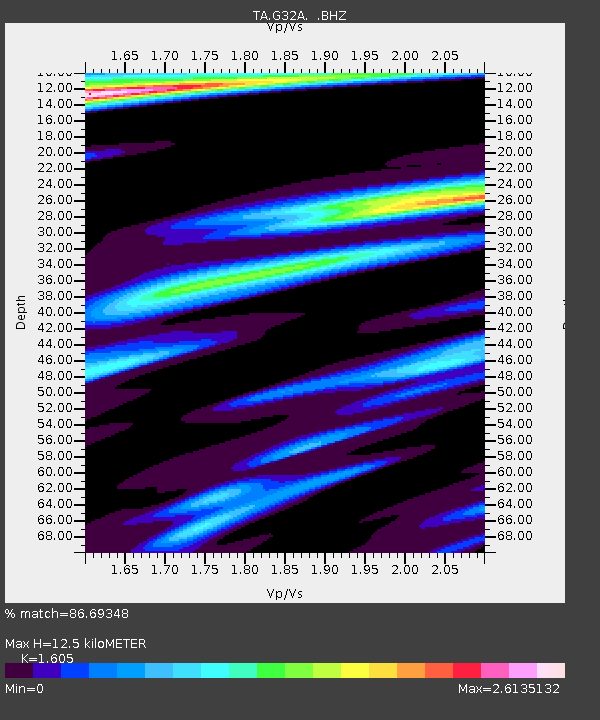
| Estimated Moho Depth: |
12.5 km |
| Estimated Crust Vp/Vs: |
1.61 |
| Assumed Crust Vp: |
6.552 km/s |
| Estimated Crust Vs: |
4.083 km/s |
| Estimated Crust Poisson's Ratio: |
0.18 |
|
| Radial Match: |
86.69348 % |
| Radial Bump: |
384 |
| Transverse Match: |
76.242805 % |
| Transverse Bump: |
400 |
| SOD ConfigId: |
408116 |
| Insert Time: |
2012-01-01 04:27:18.682 +0000 |
| GWidth: |
2.5 |
| Max Bumps: |
400 |
| Tol: |
0.001 |
|

Signal To Noise
| Channel | StoN | STA | LTA |
| TA:G32A: :BHZ:20110804T14:01:53.54999Z | 14.6478 | 1.3053266E-6 | 8.911417E-8 |
| TA:G32A: :BHN:20110804T14:01:53.54999Z | 2.8396327 | 8.621602E-7 | 3.036168E-7 |
| TA:G32A: :BHE:20110804T14:01:53.54999Z | 4.060421 | 9.634161E-7 | 2.3727002E-7 |
| Arrivals |
| Ps | 1.2 SECOND |
| PpPs | 4.7 SECOND |
| PsPs/PpSs | 6.0 SECOND |


