You are here: Home > Network List > TA - USArray Transportable Network (new EarthScope stations) Stations List
> Station H35A Sunnyside Ranch, Fairfax, MN, USA > Earthquake Result Viewer
H35A Sunnyside Ranch, Fairfax, MN, USA - Earthquake Result Viewer
| Earthquake location: |
Kuril Islands |
| Earthquake latitude/longitude: |
48.8/154.8 |
| Earthquake time(UTC): |
2011/08/04 (216) 13:51:34 GMT |
| Earthquake Depth: |
36 km |
| Earthquake Magnitude: |
6.0 MB, 5.8 MS, 6.1 MW, 6.0 MW |
| Earthquake Catalog/Contributor: |
WHDF/NEIC |
|
| Network: |
TA USArray Transportable Network (new EarthScope stations) |
| Station: |
H35A Sunnyside Ranch, Fairfax, MN, USA |
| Lat/Lon: |
44.70 N/94.83 W |
| Elevation: |
345 m |
|
| Distance: |
68.8 deg |
| Az: |
45.812 deg |
| Baz: |
318.368 deg |
| Ray Param: |
0.05601987 |
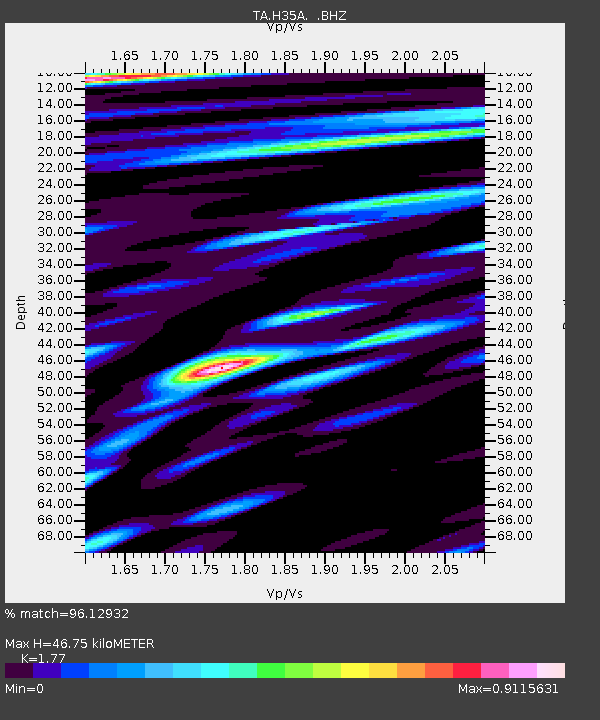
| Estimated Moho Depth: |
46.75 km |
| Estimated Crust Vp/Vs: |
1.77 |
| Assumed Crust Vp: |
6.571 km/s |
| Estimated Crust Vs: |
3.712 km/s |
| Estimated Crust Poisson's Ratio: |
0.27 |
|
| Radial Match: |
96.12932 % |
| Radial Bump: |
400 |
| Transverse Match: |
79.94427 % |
| Transverse Bump: |
400 |
| SOD ConfigId: |
408116 |
| Insert Time: |
2012-01-01 04:30:02.714 +0000 |
| GWidth: |
2.5 |
| Max Bumps: |
400 |
| Tol: |
0.001 |
|
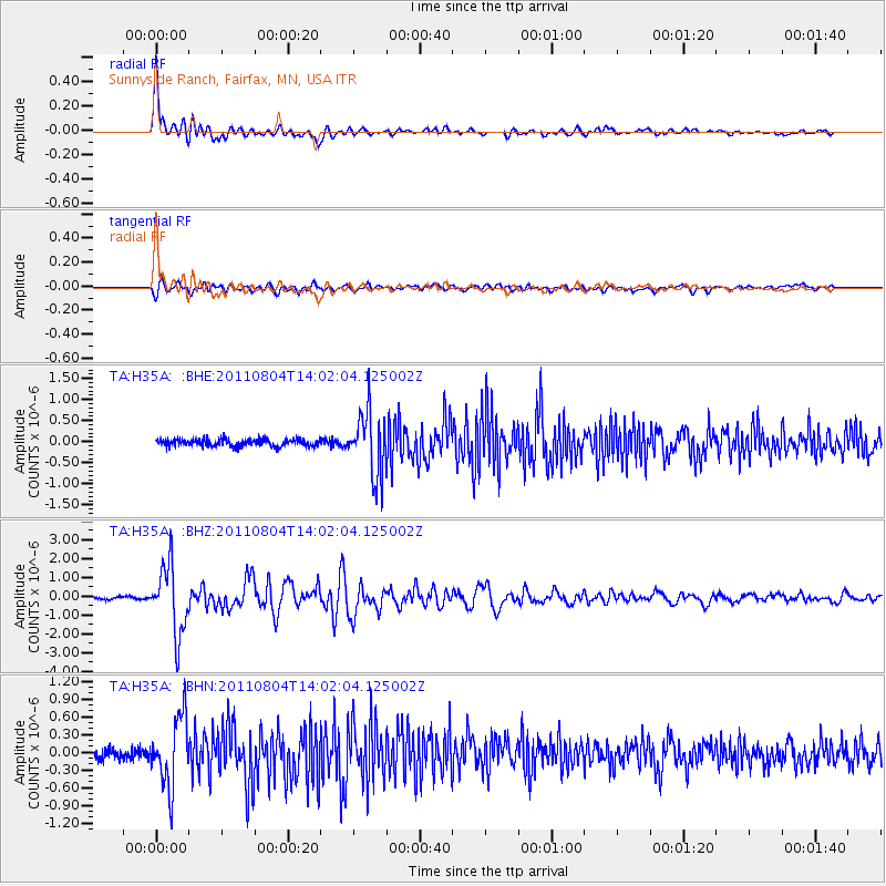
Signal To Noise
| Channel | StoN | STA | LTA |
| TA:H35A: :BHZ:20110804T14:02:04.125002Z | 25.933014 | 1.8290558E-6 | 7.0530014E-8 |
| TA:H35A: :BHN:20110804T14:02:04.125002Z | 6.1310396 | 5.8389054E-7 | 9.523516E-8 |
| TA:H35A: :BHE:20110804T14:02:04.125002Z | 9.044892 | 7.4738233E-7 | 8.2630315E-8 |
| Arrivals |
| Ps | 5.7 SECOND |
| PpPs | 19 SECOND |
| PsPs/PpSs | 25 SECOND |


