You are here: Home > Network List > TA - USArray Transportable Network (new EarthScope stations) Stations List
> Station M37A Trindle Farm, Earlham, IA, USA > Earthquake Result Viewer
M37A Trindle Farm, Earlham, IA, USA - Earthquake Result Viewer
| Earthquake location: |
Kuril Islands |
| Earthquake latitude/longitude: |
48.8/154.8 |
| Earthquake time(UTC): |
2011/08/04 (216) 13:51:34 GMT |
| Earthquake Depth: |
36 km |
| Earthquake Magnitude: |
6.0 MB, 5.8 MS, 6.1 MW, 6.0 MW |
| Earthquake Catalog/Contributor: |
WHDF/NEIC |
|
| Network: |
TA USArray Transportable Network (new EarthScope stations) |
| Station: |
M37A Trindle Farm, Earlham, IA, USA |
| Lat/Lon: |
41.40 N/94.06 W |
| Elevation: |
325 m |
|
| Distance: |
71.6 deg |
| Az: |
47.656 deg |
| Baz: |
319.519 deg |
| Ray Param: |
0.054136254 |
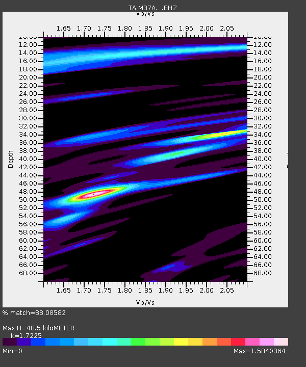
| Estimated Moho Depth: |
48.5 km |
| Estimated Crust Vp/Vs: |
1.72 |
| Assumed Crust Vp: |
6.498 km/s |
| Estimated Crust Vs: |
3.772 km/s |
| Estimated Crust Poisson's Ratio: |
0.25 |
|
| Radial Match: |
88.08582 % |
| Radial Bump: |
400 |
| Transverse Match: |
83.615875 % |
| Transverse Bump: |
400 |
| SOD ConfigId: |
408116 |
| Insert Time: |
2012-01-01 04:32:34.529 +0000 |
| GWidth: |
2.5 |
| Max Bumps: |
400 |
| Tol: |
0.001 |
|
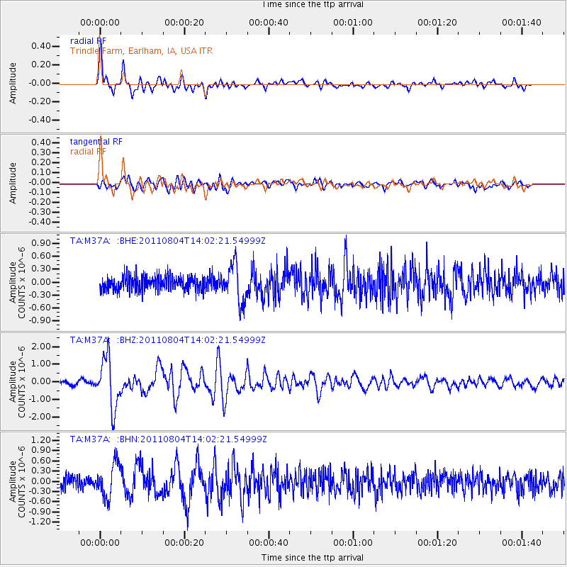
Signal To Noise
| Channel | StoN | STA | LTA |
| TA:M37A: :BHZ:20110804T14:02:21.54999Z | 12.267624 | 1.4507868E-6 | 1.1826143E-7 |
| TA:M37A: :BHN:20110804T14:02:21.54999Z | 3.0032768 | 5.0181455E-7 | 1.67089E-7 |
| TA:M37A: :BHE:20110804T14:02:21.54999Z | 2.8939726 | 4.490307E-7 | 1.5516066E-7 |
| Arrivals |
| Ps | 5.6 SECOND |
| PpPs | 20 SECOND |
| PsPs/PpSs | 25 SECOND |


