You are here: Home > Network List > TA - USArray Transportable Network (new EarthScope stations) Stations List
> Station R38A Fenwick Farm, Montrose, MO, USA > Earthquake Result Viewer
R38A Fenwick Farm, Montrose, MO, USA - Earthquake Result Viewer
| Earthquake location: |
Kuril Islands |
| Earthquake latitude/longitude: |
48.8/154.8 |
| Earthquake time(UTC): |
2011/08/04 (216) 13:51:34 GMT |
| Earthquake Depth: |
36 km |
| Earthquake Magnitude: |
6.0 MB, 5.8 MS, 6.1 MW, 6.0 MW |
| Earthquake Catalog/Contributor: |
WHDF/NEIC |
|
| Network: |
TA USArray Transportable Network (new EarthScope stations) |
| Station: |
R38A Fenwick Farm, Montrose, MO, USA |
| Lat/Lon: |
38.19 N/93.91 W |
| Elevation: |
237 m |
|
| Distance: |
74.2 deg |
| Az: |
49.728 deg |
| Baz: |
320.225 deg |
| Ray Param: |
0.05245722 |
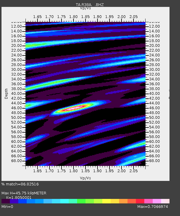
| Estimated Moho Depth: |
45.75 km |
| Estimated Crust Vp/Vs: |
1.81 |
| Assumed Crust Vp: |
6.498 km/s |
| Estimated Crust Vs: |
3.6 km/s |
| Estimated Crust Poisson's Ratio: |
0.28 |
|
| Radial Match: |
86.82516 % |
| Radial Bump: |
400 |
| Transverse Match: |
67.3988 % |
| Transverse Bump: |
400 |
| SOD ConfigId: |
408116 |
| Insert Time: |
2012-01-01 04:34:09.028 +0000 |
| GWidth: |
2.5 |
| Max Bumps: |
400 |
| Tol: |
0.001 |
|

Signal To Noise
| Channel | StoN | STA | LTA |
| TA:R38A: :BHZ:20110804T14:02:36.500002Z | 11.528223 | 8.298679E-7 | 7.198576E-8 |
| TA:R38A: :BHN:20110804T14:02:36.500002Z | 5.324857 | 2.5530753E-7 | 4.794636E-8 |
| TA:R38A: :BHE:20110804T14:02:36.500002Z | 4.075027 | 2.3608571E-7 | 5.7934763E-8 |
| Arrivals |
| Ps | 5.9 SECOND |
| PpPs | 19 SECOND |
| PsPs/PpSs | 25 SECOND |


