You are here: Home > Network List > TA - USArray Transportable Network (new EarthScope stations) Stations List
> Station O39A Kirksville, MO, USA > Earthquake Result Viewer
O39A Kirksville, MO, USA - Earthquake Result Viewer
| Earthquake location: |
Kuril Islands |
| Earthquake latitude/longitude: |
48.8/154.8 |
| Earthquake time(UTC): |
2011/08/04 (216) 13:51:34 GMT |
| Earthquake Depth: |
36 km |
| Earthquake Magnitude: |
6.0 MB, 5.8 MS, 6.1 MW, 6.0 MW |
| Earthquake Catalog/Contributor: |
WHDF/NEIC |
|
| Network: |
TA USArray Transportable Network (new EarthScope stations) |
| Station: |
O39A Kirksville, MO, USA |
| Lat/Lon: |
40.25 N/92.54 W |
| Elevation: |
282 m |
|
| Distance: |
73.3 deg |
| Az: |
47.507 deg |
| Baz: |
320.46 deg |
| Ray Param: |
0.053068843 |
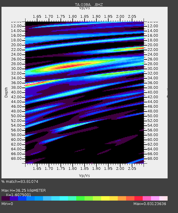
| Estimated Moho Depth: |
36.25 km |
| Estimated Crust Vp/Vs: |
1.61 |
| Assumed Crust Vp: |
6.498 km/s |
| Estimated Crust Vs: |
4.042 km/s |
| Estimated Crust Poisson's Ratio: |
0.18 |
|
| Radial Match: |
83.81074 % |
| Radial Bump: |
400 |
| Transverse Match: |
73.014885 % |
| Transverse Bump: |
400 |
| SOD ConfigId: |
408116 |
| Insert Time: |
2012-01-01 04:34:22.935 +0000 |
| GWidth: |
2.5 |
| Max Bumps: |
400 |
| Tol: |
0.001 |
|

Signal To Noise
| Channel | StoN | STA | LTA |
| TA:O39A: :BHZ:20110804T14:02:31.17499Z | 5.11943 | 1.5471439E-6 | 3.022102E-7 |
| TA:O39A: :BHN:20110804T14:02:31.17499Z | 2.7298162 | 6.964988E-7 | 2.5514493E-7 |
| TA:O39A: :BHE:20110804T14:02:31.17499Z | 2.5028973 | 5.5017983E-7 | 2.1981718E-7 |
| Arrivals |
| Ps | 3.5 SECOND |
| PpPs | 14 SECOND |
| PsPs/PpSs | 18 SECOND |


