You are here: Home > Network List > G - GEOSCOPE Stations List
> Station DRV Dumont d'Urville, Terre Adelie (Antartica) > Earthquake Result Viewer
DRV Dumont d'Urville, Terre Adelie (Antartica) - Earthquake Result Viewer
| Earthquake location: |
Vanuatu Islands |
| Earthquake latitude/longitude: |
-13.7/166.6 |
| Earthquake time(UTC): |
1991/10/12 (285) 16:26:25 GMT |
| Earthquake Depth: |
47 km |
| Earthquake Magnitude: |
5.9 MB, 6.2 MS |
| Earthquake Catalog/Contributor: |
WHDF/NEIC |
|
| Network: |
G GEOSCOPE |
| Station: |
DRV Dumont d'Urville, Terre Adelie (Antartica) |
| Lat/Lon: |
66.67 S/140.01 E |
| Elevation: |
40 m |
|
| Distance: |
55.8 deg |
| Az: |
192.446 deg |
| Baz: |
31.729 deg |
| Ray Param: |
0.06443075 |
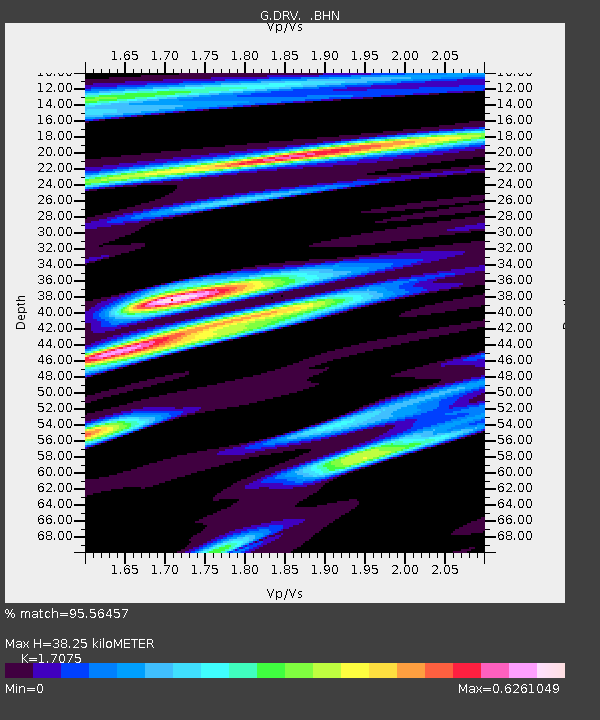
| Estimated Moho Depth: |
38.25 km |
| Estimated Crust Vp/Vs: |
1.71 |
| Assumed Crust Vp: |
6.39 km/s |
| Estimated Crust Vs: |
3.742 km/s |
| Estimated Crust Poisson's Ratio: |
0.24 |
|
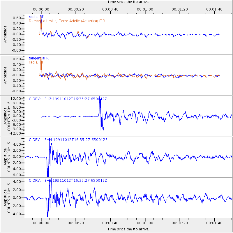
| Radial Match: |
95.56457 % |
| Radial Bump: |
400 |
| Transverse Match: |
81.07139 % |
| Transverse Bump: |
400 |
| SOD ConfigId: |
16938 |
| Insert Time: |
2010-02-26 21:58:11.664 +0000 |
| GWidth: |
2.5 |
| Max Bumps: |
400 |
| Tol: |
0.001 |
|
Signal To Noise
| Channel | StoN | STA | LTA |
| G:DRV: :BHN:19911012T16:35:27.650012Z | 10.293056 | 2.1714645E-6 | 2.1096403E-7 |
| G:DRV: :BHE:19911012T16:35:27.650012Z | 6.697127 | 1.53433E-6 | 2.2910271E-7 |
| G:DRV: :BHZ:19911012T16:35:27.650012Z | 17.073906 | 4.609376E-6 | 2.699661E-7 |
| Arrivals |
| Ps | 4.5 SECOND |
| PpPs | 15 SECOND |
| PsPs/PpSs | 20 SECOND |


