You are here: Home > Network List > TA - USArray Transportable Network (new EarthScope stations) Stations List
> Station P40A Paris, MO, USA > Earthquake Result Viewer
P40A Paris, MO, USA - Earthquake Result Viewer
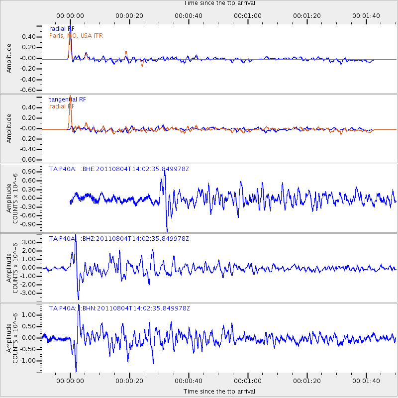
| Earthquake location: |
Kuril Islands |
| Earthquake latitude/longitude: |
48.8/154.8 |
| Earthquake time(UTC): |
2011/08/04 (216) 13:51:34 GMT |
| Earthquake Depth: |
36 km |
| Earthquake Magnitude: |
6.0 MB, 5.8 MS, 6.1 MW, 6.0 MW |
| Earthquake Catalog/Contributor: |
WHDF/NEIC |
|
| Network: |
TA USArray Transportable Network (new EarthScope stations) |
| Station: |
P40A Paris, MO, USA |
| Lat/Lon: |
39.53 N/92.05 W |
| Elevation: |
225 m |
|
| Distance: |
74.1 deg |
| Az: |
47.678 deg |
| Baz: |
320.824 deg |
| Ray Param: |
0.052533265 |
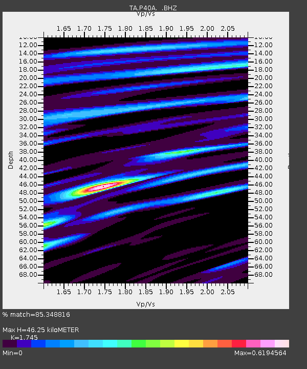
| Estimated Moho Depth: |
46.25 km |
| Estimated Crust Vp/Vs: |
1.75 |
| Assumed Crust Vp: |
6.498 km/s |
| Estimated Crust Vs: |
3.724 km/s |
| Estimated Crust Poisson's Ratio: |
0.26 |
|
| Radial Match: |
85.348816 % |
| Radial Bump: |
379 |
| Transverse Match: |
69.9329 % |
| Transverse Bump: |
400 |
| SOD ConfigId: |
408116 |
| Insert Time: |
2012-01-01 04:34:54.369 +0000 |
| GWidth: |
2.5 |
| Max Bumps: |
400 |
| Tol: |
0.001 |
|
Signal To Noise
| Channel | StoN | STA | LTA |
| TA:P40A: :BHZ:20110804T14:02:35.849978Z | 17.092066 | 1.7209859E-6 | 1.00689164E-7 |
| TA:P40A: :BHN:20110804T14:02:35.849978Z | 5.5564227 | 6.4846625E-7 | 1.1670571E-7 |
| TA:P40A: :BHE:20110804T14:02:35.849978Z | 5.365015 | 5.134059E-7 | 9.569514E-8 |
| Arrivals |
| Ps | 5.5 SECOND |
| PpPs | 19 SECOND |
| PsPs/PpSs | 24 SECOND |


