You are here: Home > Network List > TA - USArray Transportable Network (new EarthScope stations) Stations List
> Station O40A La Belle, MO, USA > Earthquake Result Viewer
O40A La Belle, MO, USA - Earthquake Result Viewer
| Earthquake location: |
Kuril Islands |
| Earthquake latitude/longitude: |
48.8/154.8 |
| Earthquake time(UTC): |
2011/08/04 (216) 13:51:34 GMT |
| Earthquake Depth: |
36 km |
| Earthquake Magnitude: |
6.0 MB, 5.8 MS, 6.1 MW, 6.0 MW |
| Earthquake Catalog/Contributor: |
WHDF/NEIC |
|
| Network: |
TA USArray Transportable Network (new EarthScope stations) |
| Station: |
O40A La Belle, MO, USA |
| Lat/Lon: |
40.12 N/91.87 W |
| Elevation: |
206 m |
|
| Distance: |
73.7 deg |
| Az: |
47.181 deg |
| Baz: |
320.798 deg |
| Ray Param: |
0.052783683 |
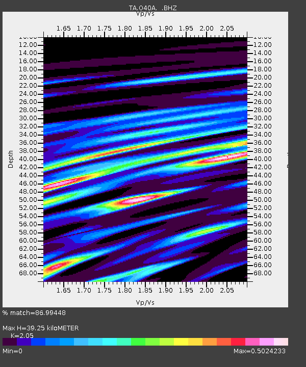
| Estimated Moho Depth: |
39.25 km |
| Estimated Crust Vp/Vs: |
2.05 |
| Assumed Crust Vp: |
6.498 km/s |
| Estimated Crust Vs: |
3.17 km/s |
| Estimated Crust Poisson's Ratio: |
0.34 |
|
| Radial Match: |
86.99448 % |
| Radial Bump: |
368 |
| Transverse Match: |
80.34922 % |
| Transverse Bump: |
400 |
| SOD ConfigId: |
408116 |
| Insert Time: |
2012-01-01 04:34:56.246 +0000 |
| GWidth: |
2.5 |
| Max Bumps: |
400 |
| Tol: |
0.001 |
|

Signal To Noise
| Channel | StoN | STA | LTA |
| TA:O40A: :BHZ:20110804T14:02:33.67499Z | 30.638012 | 1.773458E-6 | 5.7884243E-8 |
| TA:O40A: :BHN:20110804T14:02:33.67499Z | 6.305165 | 6.352234E-7 | 1.0074652E-7 |
| TA:O40A: :BHE:20110804T14:02:33.67499Z | 5.047046 | 5.47769E-7 | 1.08532596E-7 |
| Arrivals |
| Ps | 6.5 SECOND |
| PpPs | 18 SECOND |
| PsPs/PpSs | 24 SECOND |


